


|
||

|

|
|

|
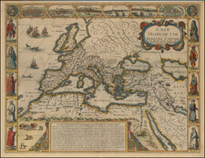
Imagining the Roman Empire
Striking example of Speed's decorative map of the Roman Empire, with decorative borders.
This map was featured in the first atlas of the world published by an Englishman, Prospect of the Most Famous Parts of the World (1627).
The map focuses on the Mediterranean and the regions dominated by Rome at the height of its empire. The map shows the Red Sea, the Middle East, Anatolia, and much of the Arabian Peninsula. It stretches from North Africa to the British Isles, with the lands of the Germanic tribes stretching to the northeast.
Roman settlements, including Londinium and Lutetia (Paris), are scattered across the region. Speed has adopted the ancient names for places; for example, the Black Sea is the Euxine Sea, while the Mediterranean is the Middle Land Sea. In a large text box in the interior of Africa is an overview of the “Beginning Increase & Height” of the Roman Empire.
The map is studded with animals. At sea there is a pitched sea battle, a single vessel, and two sea monsters. In Africa are a pair of lions, a camel train, a cheetah, and a pair of ostriches.
Some of the most notable features of the map are its decorative borders in the carte-a-figures style. Along the left and right sides are pictures of typical costumes for men and women from Spain, Italy, Turkey, Egypt, and Morocco. In the upper corners are images of Romulus, builder of Rome, and an allegorical figure of Rome itself. Along the upper edge is a bird’s-eye view of Rome, Genoa, Jerusalem, Venice, Constantinople, and a plan of Alexandria.
Historical maps like this were extremely popular in the early modern period, as antiquarianism was a popular subject of study. People wanted to be able to locate ancient and Biblical places and graph them onto their known world.
Speed died in 1629, and George Humble passed in 1640. The copperplates from the Prospect passed to George’s son, William Humble. Humble reissued the maps on an ad hoc basis before passing the plates to William Garrett, who passed them to Roger Rea.
John Speed (1551 or '52 - 28 July 1629) was the best known English mapmaker of the Stuart period. Speed came to mapmaking late in life, producing his first maps in the 1590s and entering the trade in earnest when he was almost 60 years old.
John Speed's fame, which continues to this day, lies with two atlases, The Theatre of the Empire of Great Britaine (first published 1612), and the Prospect of the Most Famous Parts of the World (1627). While The Theatre ... started as solely a county atlas, it grew into an impressive world atlas with the inclusion of the Prospect in 1627. The plates for the atlas passed through many hands in the 17th century, and the book finally reached its apotheosis in 1676 when it was published by Thomas Bassett and Richard Chiswell, with a number of important maps added for the first time.
![[ Ostia - Ancient Port of Rome ] Claudii Et Traiani Impp Admirabilium Portuum Ostiensium Orthographia Per Stephanum Du Perach Architectum Iuxta Antiqua Vestigia Accuratissime Delineata . . . 1575](https://storage.googleapis.com/raremaps/img/small/102612.jpg)

![Les Estats de L'Empire des Turqs en Asie . . . . [Includes Cyprus]](https://storage.googleapis.com/raremaps/img/small/50415.jpg)