This item has been sold, but you can enter your email address to be notified if another example becomes available.


|
||

|

|
|

|
Stock# 82221
Description
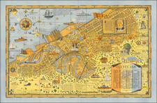
Second State of the First Map of Disneyland.
Early pictorial map of the Disneyland theme park, from 1958.
Disneyland maps were first issued in 1858, created by Sam McKim. Later maps were issued in 1961, 1962 and 1964 (two states).
This is the second state, which pre-dates the addition of Cascade Falls in Adventure Land, which would appear immediately above the Mark Twain Steamboat.
There are three states of the 1958 map (a, b and c), which can be identified as follows:
- All states have the 1958 copyright in the lower right-hand corner and have an orange border.
- The Viewliner appears in Tomorrowland. This is only present in 1958a
- The 1958a state and the 1958c state map show the Matterhorn and the Monorail in Tomorrowland. The Viewliner in Tomorrowland is gone, as well as the Junior Autopia, replaced by the Fantasyland Autopia.
- In 1958a, the Jungle Cruise water is green. In 1958b and 958c map the water is blue.
- In 1958c, Cascade Peak in Adventure Land has been removed.

![[ California Missions ] El C. Valentin Canalizo General De Division, Gobernador y Comandante General del Departmento de México [Mexico: Aug. 23, 1843]](https://storage.googleapis.com/raremaps/img/small/101827.jpg)