


|
||

|

|
|

|
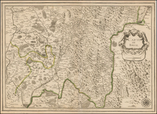
An unusual example of Melchior Tavernier and Nicolas Sanson's double-page engraved historical map of classical France.
This map divides France according to its provinces during classical times. Further, the map names the cities in France according to their Classical names, for example, Paris is named Lutetia. The text to the left of the map describes these subdivisions and the organizational region of the country during this time.
The text sheet was published in 1700, most likely by Hubert Jaillot, but maintains Sanson's imprint. While the map and text often appear together in atlases, it is rare to see the two joined as a single sheet.
Melchior Tavernier was a member of a large family involved in the publishing trade in Paris in the early years of the seventeenth century. Early in his career, he apparently collaborated with Henricus Hondius, as at least one of his early maps references Tavernier as the seller of a map engraved in Amsterdam, by Hondius. He is probably best known for his publication of a map of the Post Roads of France, which was copied many times until the end of the century. He also issued an atlas under the same title as J. le Clerc's Theatre Geographique, using many of Le Clerc's maps, but incorporating others from different sources. He published composite atlases and also published works for other cartographers, including N. Sanson, N. Tassin, and P. Bertius. He is not to be confused with his nephew of the same name (1594-1665), who also engraved maps for Nicolas Sanson.
Nicholas Sanson (1600-1667) is considered the father of French cartography in its golden age from the mid-seventeenth century to the mid-eighteenth. Over the course of his career he produced over 300 maps; they are known for their clean style and extensive research. Sanson was largely responsible for beginning the shift of cartographic production and excellence from Amsterdam to Paris in the later-seventeenth century.
Sanson was born in Abbeville in Picardy. He made his first map at age twenty, a wall map of ancient Gaul. Upon moving to Paris, he gained the attention of Cardinal Richelieu, who made an introduction of Sanson to King Louis XIII. This led to Sanson's tutoring of the king and the granting of the title ingenieur-geographe du roi.
His success can be chalked up to his geographic and research skills, but also to his partnership with Pierre Mariette. Early in his career, Sanson worked primarily with the publisher Melchior Tavernier. Mariette purchased Tavernier’s business in 1644. Sanson worked with Mariette until 1657, when the latter died. Mariette’s son, also Pierre, helped to publish the Cartes générales de toutes les parties du monde (1658), Sanson' atlas and the first French world atlas.

![[Grand View of Paris] Lutetiae, vulgo, Paris, Urbis Galliarum Primariæ, Non Europæ Solius, Sed Orbis Totius Celeberrimæ Prospectus](https://storage.googleapis.com/raremaps/img/small/77258.jpg)
![[Grenoble 1968 Winter Olympics] L'Alpe D'Huez France - Isere](https://storage.googleapis.com/raremaps/img/small/84340.jpg)