|
||

|

|
|

|
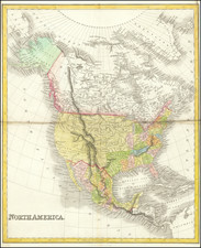
Interesting map of North America, engraved by John Gibson in London.
The map includes a large section in the Northwestern part of the continent entitled "Parts Undiscovered," at a period when the British were actively funding efforts to discover the Northwest Passage and the Hudson's Bay Company was pushing ever deeper the region, in search of furs, etc.
California Is "New Albion", with Quivira also shown above the headwaters of the Colorado River. A curious east-west mountain range is shown in California, with two Indian Tribal regions shown between the Colorado River and the Mississippi River, the "Cansees," Apaches. Further east, the "Charokes' are shown in what would become Tennessee.
Fort Crevecor appears below Lake Michigan, but no sign of Chicago.
Senis or Tekas is shown, as is [New] Orleans.
John Gibson flourished in London from 1748 to 1773. He was most likely born ca. 1724. As a young man he was apprenticed to John Blunbell of the Stationers Company, and then to John Pine. He was made free of the Company in 1748. Gibson proved a talented geographer and engraver who produced numerous maps, especially for books and magazines. He worked in collaboration with other map sellers such as Emanuel Bowen and John Roque. His best-known work was the pocket atlas, The Atlas Minimus (1758). Although little is known about his life beyond his publications, he was imprisoned for debt in King’s Bench from May to June of 1765.

![[ Chinese Voyages To America, etc. ] Memoires De Litterature, Tires Des Registres De L'Academie Royale Des Inscriptions et Belles-Lettres Depuis l' annee M. DCC. XVIII. julques & compris l'annee M. DCC. XXV Tome Quarante-Neuvieme](https://storage.googleapis.com/raremaps/img/small/101296.jpg)