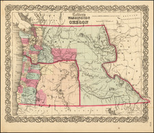
|
||

|

|
|

|
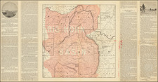
From one of the Most Detailed Surveys of the Northern Rockies.
Fascinating map showing the northern Rocky Mountains around the Utah-Idaho-Wyoming border in remarkable topological and geographical detail.
The map shows the region between Bear Lake and the Green River, with the Wyoming and Salt River Ranges in the center. In the far southwest of the map is the Utah and Northern Railroad.
Surveyed by Ferdinand Hayden and his colleagues intermittently between the late 1860s and 1878, this map was published in 1879. The map is remarkably detailed in its treatment and names a number of early townships and outposts including Montpellier and Bennington. Roads and railroads are shown.
The Hayden Survey -- The Greatest of the Four Great Surveys
The late 1860s and early 1870s saw four great surveys of the American West: the King Survey, which mapped the region around the 40th parallel; the Wheeler Survey, which attempted (unsuccessfully) to map the whole of the territories and western states at a moderate scale; the Powell Survey, which focused on the southwest and the Grand Canyon region; and finally the Hayden survey, which surveyed the territory of Colorado as well as the last great unmapped region of the Lower Forty-Eight: the Yellowstone Basin.
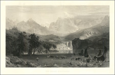
The Hayden Survey's most prolific years were 1871-72, which were dedicated to northwestern Wyoming. Up until then, the Yellowstone had been briefly explored by two previous surveys, including the Folsom-Cook and the Washburn-Langford-Doane expeditions of 1869 and 1870 respectively. However, these surveys lacked the resources of the Hayden Surveys: full government support, tens of thousands of dollars, and over sixty men. The Hayden Survey relentlessly worked on the territory, and its reports--most notably in the photos published which were taken by William H. Jackson--were the reason why the senate approved Yellowstone as the nation's first national park in 1871.
The area around Jackson Hole was surveyed primarily in the summer of 1872. In that year, the expedition split up between a group dedicated to the Yellowstone, led by Hayden, and one dedicated to the Snake River area, led by James Stevenson. The latter group primarily spent the majority of the summer focused on the Tetons and Jackson's Hole. During this part of the survey, William Jackson took the first photos of the Tetons, and James Stevenson and his colleague N. P. Langford became the first Anglo-Americans to climb Grand Teton.
The Hayden Survey would return to the Jackson Hole area in 1877 and 1878, however, the bulk of the mapping had been conducted in 1872. 1878 was the final field year for all the four great surveys, after which the federal government, wary of the often conflicting politics of the parties, founded the USGS to consolidate the surveying exercise. These Great Surveys represented the last triumph of the age of discovery in the American West.
Ferdinand Vandeveer Hayden, known to the Sioux as "man-who-picks-up-stones-running," stands among the pantheon of eminent geologists of the 19th century.
Hayden's academic career commenced at Oberlin College, and he furthered his education at Albany Medical College, where he received his M.D. in 1853. Despite his medical training, Hayden was primarily engaged in geology, a field to which he would dedicate his life's work.
Hayden commenced his geological career with a survey in the Nebraska Territory in 1856. In 1859 and 1860, he conducted further exploratory work in the Rocky Mountains, particularly in Colorado, which was then part of the Nebraska and Kansas territories. His early work in the field earned him the respect of Native American tribes, with the Sioux reportedly dubbing him "man-who-picks-up-stones-running" due to his avid and energetic collection of geological samples during his expeditions.
By the 1860s, Hayden had risen to prominence as a geologist and was appointed the United States Geologist for the Geological Survey of the Territories. This role would define his career, leading numerous surveys in the Western United States. Notably, from 1871 to 1872, Hayden led a survey into the region that would become Yellowstone National Park, and his reports significantly contributed to the establishment of Yellowstone as the first National Park in 1872.
Hayden's most significant contribution to geological literature was the Geological Atlas of Colorado, published in 1877. This work was the result of comprehensive surveys conducted across Colorado, meticulously documenting the state's geography and geology. The atlas offered detailed maps on a scale previously unseen, encompassing not only Colorado but adjacent areas, including parts of Utah, Arizona, and New Mexico.
Hayden's influence extended to academia, as he was affiliated with the University of Pennsylvania for a period, where he held the position of professor of geology. His academic and field work combined to form a substantial body of knowledge that would be used by future scholars and explorers.
Ferdinand V. Hayden passed away on December 22, 1887, in Philadelphia, Pennsylvania. His enduring legacy is reflected in the numerous natural features named after him, including Hayden Valley in Yellowstone and Mount Hayden in Colorado. His contributions to geology during the 19th century remain a cornerstone of American geological and geographical sciences.