


|
||

|

|
|

|
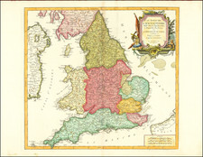
A meticulously detailed map of the Kingdom of England and the Principality of Wales by Frederick de Wit, published in Amsterdam circa 1680, distinctly divided into their respective provinces and created with the privilege of the powerful Lords of the States of Holland and West Friesland.
The cartouche features the coat of arms of England.
While the map's title claims to be highly accurate, it is essential to consider the element of salesmanship in such a statement, as is common with cartographic works of this era. Nevertheless, the map showcases the intricate network of rivers, cities, towns, and other geographical features characteristic of England and Wales at the time. With its detailed depiction of the provinces and carefully labeled locations, the map serves as a valuable resource for understanding the historical geography of the region during the 17th century.
De Wit (1629 ca.-1706) was a mapmaker and mapseller who was born in Gouda but who worked and died in Amsterdam. He moved to the city in 1648, where he opened a printing operation under the name of The Three Crabs; later, he changed the name of his shop to The White Chart. From the 1660s onward, he published atlases with a variety of maps; he is best known for these atlases and his Dutch town maps. After Frederik’s death in 1706, his wife Maria ran the shop for four years before selling it. Their son, Franciscus, was a stockfish merchant and had no interest in the map shop. At the auction to liquidate the de Wit stock, most of the plates went to Pieter Mortier, whose firm eventually became Covens & Mortier, one of the biggest cartography houses of the eighteenth century.
![[ United Kingdom ] Tabula Prima Europae](https://storage.googleapis.com/raremaps/img/small/78537.jpg)
![[ American Revolution - Satirical Warning To Dutch Commerce ] Den Door List en Geweld Aangevallen Leeuw.](https://storage.googleapis.com/raremaps/img/small/99580.jpg)
![[Wall Map of England] England and Wales Drawn from the most accurate Surveys . . . . By John Rocque](https://storage.googleapis.com/raremaps/img/small/56438.jpg)