|
||

|

|
|

|
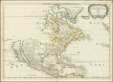
Beautiful, detailed map of the Pacific and the Americas showing colonial activity in the eighteenth century
Fine example of the De Leth's monumental map focused on the trade routes to and across the Pacific Ocean.
De Leth's map is based largely upon Nicholas De Fer's wall map of 1713. De Leth follows French models and the English American colonies are confined to the Atlantic coast of North America. The Mississippi flows into the Gulf on Mexico on the Texas coast. The Great Lakes are well formed and California is shown as an island. In the Pacific the mythical "Terre de Quir" appears joined to the Australian coastline.
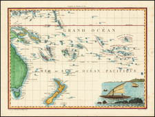
The treatment of Australia, New Zealand and Southeast Asia are also noteworthy. The map shows a continuous southern coastline of Australia running from Terre d'Edels and Terre de Leuwin, regions discover by the Dutch in early 17th Century, to the west coast of New Zealand, suggesting one continuous land mass extending nearly 11 degrees, with "Terre d'Antoine Diemens" sandwiched between cherubs holding aloft a banner describing "Nova Maris Pacifica Tabula . . . " The nearly parallel northern coastline of Australia also extends nearly 11 degrees, trailing off into a fantasy east coast north of the New Zealand Coastline.
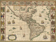
The map is centered on America and shows the tracks of famous navigators like Magellan and Schouten, who both discovered a western entrance into the Pacific Ocean. The map also shows the trade route from Europe to Southeast Asia, via Mexico and the west coast of North America. These additions serve to incorporate the Pacific into the global trade networks of Spain, the Netherlands, and, judging by the use of French and Dutch on the map, France.
The effect is heightened by detailed insets which highlight ports and cities central to trade. The beautifully engraved vignettes include a spectacular view of a Dutch trading port at the Cape of Good Hope, set within an elaborate border decorated with monkeys and wild cats and crowned with a plan of the fort. A plan of Mexico City is surrounded by scenes of native life and the Spanish Conquest of the Aztecs, as well as images of the Temple of the Sun and an underground mining operation. A third vignette features images of sugar production as practiced on slave plantations in French colonies, an addition not found in De Fer or Chatelain. Other insets includes plans of Havana, the Bay of Rio de Janeiro, Vera Cruz, Porto Bello, and the Isthmus of Panama.
Although it is a map of the Mer du Sud, the South Sea, the world's largest body of water is crowded with non-geographic features. This was a way for the De Leths to conveniently skirt certain controversial choices, like how to portray the land between Japan and North America (although the mythical island of Jesso is included), or whether and how to show a southern continent. They do choose to show the Strait of Anian, a nod to the Northwest Passage, but do not include a phantom coastline of Terre d'Anian or Terre de la Compagnie as Chatelain and De Fer did.
The map survives in several states, including:
- A proof state, pre-dating the inclusion of the text box below the Mexico City vignettes and with insets shows (added in the second state) and without the inset city plans of Rio De Janeiro, Havana and Vera Cruz (which replaced a vignette of a waterfall on the Mississippi River) and the publisher's imprint in the second line of the title. Also, one of the inset maps includes the Straits of Magellan.
- The second state adds the text box beginning with Messieurs. . . . and adds plans of Vera-Cruz, the Rio Janeiro Harbor and Havana, to the west of California. Second state also adds an inset at the top right (showing the Straits of Gibraltar) and the daily tracks of the route along the west coast of Africa.
- In the third state the insets at the bottom are replaced and now show Porto Bello and the Isthmus of Panama.
The present example is state 3, with fine wide margins and a nice dark impression.
The popular misconception of California as an island can be found on European maps from the sixteenth through the eighteenth centuries. From its first portrayal on a printed map by Diego Gutiérrez, in 1562, California was shown as part of North America by mapmakers, including Gerardus Mercator and Abraham Ortelius. In the 1620s, however, it began to appear as an island in several sources. While most of these show the equivalent of the modern state of California separated from the continent, others, like a manuscript chart by Joao Teixeira Albernaz I (ca. 1632) now in the collection of the National Library of Brasil shows the entire western half of North Americas as an island.
The myth of California as an island was most likely the result of the travel account of Sebastian Vizcaino, who had been sent north up the shore of California in 1602. A Carmelite friar, Fray Antonio de la Ascensión, accompanied him. Ascension described the land as an island and around 1620 sketched maps to that effect. Normally, this information would have been reviewed and locked in the Spanish repository, the Casa de la Contratación. However, the manuscript maps were intercepted in the Atlantic by the Dutch, who took them to Amsterdam where they began to circulate. Ascensión also published descriptions of the insular geography in Juan Torquemada’s Monarquia Indiana (1613) (with the island details curtailed somewhat) and in his own Relación breve of ca. 1620.
The first known maps to show California as an island were on the title pages of Antonio de Herrera’s Descripción de las Indias Occidentales (1622) and Jacob le Maire's Spieghel Der Australische Navigatie (1622). Two early examples of larger maps are those by Abraham Goos (1624) and another by Henry Briggs, which was included in Samuel Purchas’ Hakluytus Posthumus or Purchas his Pilgrimes (1625). In addition to Briggs and Goos, prominent practitioners like Jan Jansson and Nicolas Sanson adopted the new island and the practice became commonplace. John Speed’s map (1626-7), based on Briggs’ work, is well known for being one of the first to depict an insular California.
The island of California became a fixture on mid- and late-seventeenth century maps. The island suggested possible links to the Northwest Passage, with rivers in the North American interior supposedly connecting to the sea between California and the mainland. Furthermore, Francis Drake had landed in northern California on his circumnavigation (1577-80) and an insular California suggested that Spanish power in the area could be questioned.
Not everyone was convinced, however. Father Eusebio Kino, after extensive travels in what is now California, Arizona, and northern Mexico concluded that the island was actually a peninsula and published a map refuting the claim (Paris, 1705). Another skeptic was Guillaume De L’Isle. In 1700, De L’Isle discussed “whether California is an Island or a part of the continent” with J. D. Cassini; the letter was published in 1715. After reviewing all the literature available to him in Paris, De L’Isle concluded that the evidence supporting an insular California was not trustworthy. He also cited more recent explorations by the Jesuits (including Kino) that disproved the island theory. Later, in his map of 1722 (Carte d’Amerique dressee pour l’usage du Roy), De L’Isle would abandon the island theory entirely.
Despite Kino’s and De L’Isle’s work, California as an island remained common on maps until the mid-eighteenth century. De L’Isle’s son-in-law, Philippe Buache, for example, remained an adherent of the island depiction for some time. Another believer was Herman Moll, who reported that California was unequivocally an island, for he had had sailors in his offices that claimed to have circumnavigated it. In the face of such skepticism, the King of Spain, Ferdinand VII, had to issue a decree in 1747 proclaiming California to be a peninsula connected to North America; the geographic chimera, no matter how appealing, was not to be suffered any longer, although a few final maps were printed with the lingering island.