


|
||

|

|
|

|
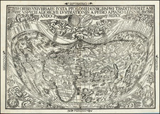
First State, Original Hand-Color. The First Obtainable Printed Map To Use the Word "America," and a Tantalizing Pre-Magellanic Look at the Straits of Magellan. One of the Great World Maps.
Apian's renowned 1520 cordiform map of the world, the earliest of his world maps and a map one of immense cartographic importance as the first obtainable map to name the Americas. This was the first published map to base its cartography on Martin Waldseemüller's foundational 12-sheet map of the world, known in only one copy and obtained by the Library of Congress for $10,000,000. The map is considered one of the cornerstones of any collections of Renaissance cartography and of early maps of the Americas.
This remarkable woodblock was produced by the leading German humanist Peter Apian, likely engraved by Lorenz Fries (whose initials appear in the lower right), and printed in Antwerp in 1520 as part of the Ioannis Camertis Minoritani, Artium, et Sacrae Theologiae Doctoris. The map shows the world in a heart-shaped projection, stretching from an array of islands in the Pacific westwards through an elongated Malay Peninsula and stunted India. Continuing even further west, Europe and Africa can be easily recognized, before reaching a wonderful depiction of the Americas.
While the fantastic cartographic representation, projection, and the great decorative elements are of the uppermost echelon in 16th-century maps, it is the depiction of the Americas that defines this piece. Early claims can be found throughout the region, with Spanish flags planted on North America, Central America, and Hispaniola. No Portuguese flags appear in Brazil, a curious ommission. Dates of discoveries of Columbian and other voyages are annotated and off the western coast of South America is a huge galleon. Much of the detail follows the aforementioned 1507 Waldemuller map, with North and South America disconnected.
In one important aspect, this map deviates from the Waldseemüller wall map. The wall map shows no sign of a southward termination to the South American continent, one which is remarkably evident on this map. The other famous map from this period to include a premonition of the straits of Magellan (which would not be known until 1521) were the 1515 Schoner globe gores. However, these globe gores show a great southern continent ("Brazilia Regno"), which this map lacks. It is unknown where Apian obtained this configuration, but some scholars have argued that the appearance of this strait may be a reference to a now-unknown pre-Magellanic voyage to the southernmost portion of the Antarctic continent (Henning). Some addition globe gores show a southward termination of South America, but this appears to be the only pre-Magellanic non-globe map to show this mythical seaway.
This map is a true cartographic masterpiece and critical for any collection of early mapping of the Americas.
The Waldemüller Map as Apian's Guiding Source
This map is the first obtainable derivative of the 12-sheet Waldseemüller map of 1507 that includes the naming of the Americas. Prior to the discovery of this latter map in 1901 in a Bavarian castle, it was believed that Apian's 1520 map was the first map to use the name America, as well as the earliest to utilize the truncated cordiform (heart-shaped) projection. However, the unearthing of the Waldemüller map showed that Apian had, in fact, drawn the majority of his geography from an earlier source. The map would be sold to the Library of Congress from its original German owners in 2001 for $10,000,000.
As noted by Shirley, Apian's map faithfully follows the Waldseemüller model with "a close geographic correspondence, a similarity of woodcutting style, and the same truncated cordiform." Apian's map is one of the key links to the use of Amerigo Vespucci's name (America) for the New World. Walldseemuller first suggested the use of the term "America" in his pamphlet Cosmographiae Introductio in 1507, and in the same year, produced a wall map of the world bearing the name. However, the later Waldseemüller maps, including his 1513 atlas, do not resemble his 1507 wall map nor do they mention the Americas. Since Apian was a highly regarded scholar and teacher, it is reasonable to conclude that his use of the name America in 1520 was a primary contributing factor to its survival.
The Waldseemüller map would be updated in 1522 for the Lorenz Fries edition of Waldseemuller's Geographiae, which reverts back to the 1507 cartography. It is likely that Apian's 1520 map, and the purported collaboration between the two on this project (the initials LF appear in the lower right of the map), were reasons for this reverting. Either way, after Apian's involvement, the name "America" was here to stay.