|
||

|

|
|

|
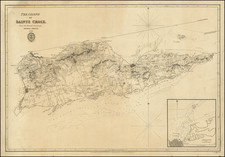
Fine Manuscript Chart of the Charlotte Amalie, St. Thomas
Well-executed manuscript chart of the Port of St. Thomas (or Charlotte Amalie), with a large inset map of the entire island of St. Thomas.
The map has been drawn by a skilled anonymous chartmaker, most likely French in origin, who has included sounding depths and notes on navigational obstructions likes rocks and sandbars. The defenses of the bay are also included, with batteries flanking the entrance, a watch tower overlooking the water, and Fort Christian protecting the town. The town itself is shown in general outline, with wharves, quays, and docks extending into the water.
At the right-hand side is a block of text describing the geographic position of and depth of waters near St. Thomas, “the farthest west of the Virgin Islands.” The text describes the best way to navigate the waters to Charlotte Amalie and describes the remnants, “carcasses,” of boats damaged and sunk in a storm in 1817. It also says that stormy winds had also shifted the waters enough to uncover rocks that could threaten ships; their position is marked on the chart.
The dating of the map comes shortly after the British occupation. The first British invasion and occupation of the island occurred in 1801. The islands were returned to Denmark in 1802. The second British occupation of the island occurred from 1807 to 1815, after the Invasion of the Danish West Indies (1807), during which they built Fort Cowell on Hassel Island.
Charlotte Amalie, St. Thomas
St. Thomas was initially inhabited by the Ciboney people, followed by the Arawaks and Caribs. European involvement began, as it often did in the Caribbean, with Christopher Columbus, who sighted the island on his second voyage in 1493.
Only nominally under the control of Spain, St. Thomas was colonized by the Dutch in 1657. Only nine years later, the Danes took over. From 1672 the island was administered by the Danish West India Company and then, from 1685, by the Brandenburg Company. Slavery was introduced in 1673 and sugar production drove the economy for the next 150 years.
In 1754/5, the island became a possession of the King of Denmark. At this time, the chief port, Charlotte Amalie (here Charlotte Amélia) became a free port, open to all international trade. This openness, and its neutrality in the Napoleonic Wars, transformed Charlotte Amalie into the largest slaving port in the Western Hemisphere in the early nineteenth century, when this map was made. During this period, Britain briefly took the island twice (1801, 1807-15), but it was returned to Denmark both times.
Due to the abolition of slavey and a drop in sugar prices, by the mid-nineteenth century St. Thomas was no longer prosperous. In 1917, the United States bought St. Thomas and two other islands for use as a naval base; they became the U.S. Virgin Islands.
![[ Virigin Islands to Trinidad and Tobago ] A Chart of the Antilles, or, Charibbee or, Caribs Islands, with the Virgin Isles . . . MDCCLXXXIV](https://storage.googleapis.com/raremaps/img/small/103660.jpg)
![[ Virgin Islands, etc ] Supplément pour les Isles Antilles, extrait des cartes Angloises](https://storage.googleapis.com/raremaps/img/small/98774.jpg)
![Amer. Sep. No. 69. Porto-Rico [and the Virgin Islands]](https://storage.googleapis.com/raremaps/img/small/42102.jpg)