|
||

|

|
|

|
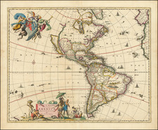
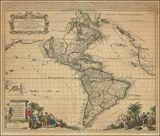
An Exceptional 17th-Century Wall Map of America. With Original Hand-Color in Full. A Previously Unknown First State.
A truly handsome example of Willem Janszoon Blaeu's early wall map of America, here in the circa 1673 Italian version by Pietro Todeschi and Giuseppi Longhi.
The map is a supreme example of the mapmaker's art from a time when wall maps became an important part of the public and private decor across Europe. In the 17th century, wall maps were elevated as symbols of worldliness and curiosity, as the European mercantile elite and aristocratic classes accumulated much wealth through overseas exploration and commerce.
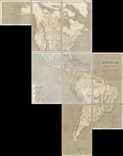
Today, all such wall maps are great rarities. They were very expensive and technically difficult to produce, and so were issued in very limited quantities. Moreover, their large size and the manner in which they were displayed made them especially vulnerable to damage, such that very few examples survive to the present day.
Willem Janszoon Blaeu's 1608 Continental Wall Maps
In Amsterdam in 1608, Willem Janszoon Blaeu produced a set of large wall maps of Europe, Asia, Africa, and the Americas. Today, original examples of these maps, published by Blaeu himself, are exceptionally rare; for instance, a survey shows only one institutional example of the Asia map, in Dresden. Despite the rarity of the original Blaeu maps, they had a colossal influence on European mapping of the continents in the 17th century, particularly through the many derivatives, reduced versions, and copies that they spawned.
In his magnum opus on early Dutch mapmaking, Gunther Schilder spends the better part of Volume V on Blaeu's set and its followers. While the original Blaeu maps practically never appear on the market today, the Italian and French derivatives appear more regularly but are still extremely rare. The primary wall map versions were by Blaeu in 1608; Scaicki in circa 1627; an anonymous Venetian version from circa 1646; a French edition by Jaillot from 1669; and this Italian copy by Pietro Todeschi (engraved by Giuseppi Longi), from 1673.
Gunther Schilder (MCN V, page 195) introduces the Todeschi-Longhi copies of the Blaeu wall map set as follows:
Another Italian imitation of Blaeu's wall maps of the four continents was engraved by Pietro Todeschi in Bologna at the beginning of the 1670s; the set was published in 1673, probably by Giuseppe Longhi. Todeschi is no stranger, since he had made the large wall map of Italy (1675) by Matthaeus Greuter as well as a large town view of Bologna (1678). Because Longhi published the map of Italy, he may also have published the four maps of the continents. This set of maps closely resembles the previously discussed Venetian edition which was probably used as a model. The copyist imitated his models very accurately in the map image, the representation of the thousands of toponyms, the decorations on the map and the decorative borders. Minor deviations occur, among other things, in the texts of the long legends, where the words are sometimes not on the same line (ill. 2.171). The map image is also engraved on four copperplates (82 x 107.5 cm in all), the decorative borders along the sides (costumed figures) and the lower edge (town views and plans) were printed from two copperplates. Some copies have a text which runs into the decorative borders. Along the upper edge runs a woodcut title in capitals. A number of sets and some single copies are known and are described below. The maps are often in very poor condition.
Differentiating the Longhi-Todeschi Edition and States
As Burden (433) elaborates, the various editions of the Blaeu wall maps of the Americas can be determined by the spellings of "MAR/ DEL NORT" and "AMERICA SEPTEN/TRIONALIS". In this case, with the spelling "MAR/ DEL NOI", we know that the map is of the Longhi-Todeschi lineage.
Burden notes: "One notable deviation from all those before is an attempt to correlate the map with the California as an island theory. This was achieved by creating an island out of Baja California." This was obviously done in an ad hoc manner, with a simple channel being cut from one side of the peninsula to the top of the Sea of Cortez. However, this is not the case in the present example, which clearly pre-dates the re-engraving to turn California into an island. Consequently this should be considered a previously unknown first state of the map.
The Todeschi edition differs in other respects from the Blaeu original; in North America, there are four toponyms that do not appear on the original (but do appear on the earlier Venetian imitation): "to the west of Davis Strait the toponym NOVA BRITANIA (on the Venetian edition: NOVA BRITANNIA), in New Brunswick the name Accadie, and further south the names Anglia nova and Nova Fiandra, names reminding us of the English and Dutch colonies." On the inset map of the Great Southern Continent "is the name Stretto Lamairo. The drawing of a coastline with the name Ant. van Diemens lant refers to the discovery of Tasmania by Abel Jansz Tasman in 1642. The addition detecta 1667 near Boach Provincia (the name Beach was more usual for the northern most tip of the Southern Continent) may be a mistake of the engraver: in 1627 Pieter Nuijts sailed along the south coast of present-day Australia." (Schilder, page 197).
Rarity
The combined censuses of Burden and Schilder indicate only the following examples: Library of Congress (2 examples); Harry Ransome Center, UT, Austin; Private American collection (2 examples, of which this might be one); RGS, London; Luneburg Museum, Germany; Societa Geografica Italiana, Rome; Koninklijke Hollandsche Lloyd, Amsterdam (untraced); Biblioteca Apostolica Vaticana.
Willem Janszoon Blaeu (1571-1638) was a prominent Dutch geographer and publisher. Born the son of a herring merchant, Blaeu chose not fish but mathematics and astronomy for his focus. He studied with the famous Danish astronomer Tycho Brahe, with whom he honed his instrument and globe making skills. Blaeu set up shop in Amsterdam, where he sold instruments and globes, published maps, and edited the works of intellectuals like Descartes and Hugo Grotius. In 1635, he released his atlas, Theatrum Orbis Terrarum, sive, Atlas novus.
Willem died in 1638. He had two sons, Cornelis (1610-1648) and Joan (1596-1673). Joan trained as a lawyer, but joined his father’s business rather than practice. After his father’s death, the brothers took over their father’s shop and Joan took on his work as hydrographer to the Dutch East India Company. Later in life, Joan would modify and greatly expand his father’s Atlas novus, eventually releasing his masterpiece, the Atlas maior, between 1662 and 1672.