|
||

|

|
|

|
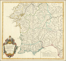
Scarce Lisbon-published road map of Portugal issued in the first year of the Peninsular War, presumably to aid in the movement of Portuguese and French troops around the varied terrain of that nation.
The map includes notes in French (lower-left) and Portuguese (lower-right) which translate as follows:
Distances from one place to another are noted by numerals placed to the right and left of the Roads.
The numbers followed by the letter L. indicate the number of leagues commonly announced in the country.
The numbers followed by the letter h. indicate the number of hours it takes a man on foot to run the distance.
The Peninsular War started in 1807 with the invasion of Portugal by a combined French Imperial and Spanish force. French troops reached and occupied Lisbon on November 30th.
This map was prepared in the aftermath of the invasion to help the occupying French and collaborating Portuguese administer the rebelling country and defend it in the event of a British invasion. While the map was prepared in Lisbon, it borrows from a French tradition of transport mapping and data visualization. In particular, the map's listing of running hours on all subsections of road is quite astounding. This kind of information was vital to military planners, but one seldom sees it on maps of any period.
Instead of rendering topography and letting the viewer guess about its effect on ease of transport through the terrain, this map sidesteps the issue of topography and simply tells the user how fast one could move across the country. The Library of Congress has an example of the map in which a contemporary user has found this wanting and added their own rendering of topography.
We do not know how the hour measurements were derived nor how accurate they were. If the data were gathered empirically, it would certainly be interesting to know more about that project.
Romão Eloy de Almeida is credited as the engraver of the map. This is interesting because, in 1808, Almeida left Portugal for Brazil, where the Portuguese court fled after the French invasion. Was he forced into making this map for the occupying forces? When in Brazil, he engraved some of that country's first banknotes. Almeida stayed in Brazil until at least the 1820s.
There is evidence of reengraving of some toponyms, suggesting the possibility of an earlier state of the map.
![[ Lisbon and Cascais ] Lisbona. Olisipo ... vulgo Lisbona Florentissimum Portugalliae Emporiu. [with] Cascale Lusitaniae Opp](https://storage.googleapis.com/raremaps/img/small/96926.jpg)