|
||

|

|
|

|
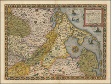
Gorgeous example of Pieter Van Den Keere's (Petrus Kaerius) map of the Duchy of Limburg, with fine inset view of Limburg and its coat of arms, from Van Den Keere's Germania Inferior id est, XVII Provinciarum ejus Novae et Exactae Tabulae Geographicae, first printed in Amsterdam in 1617.
Many rivers, towns, and cities, including Maastricht on the Mosa (Meuse), Liege, Aix (Aachen) on the Worm (Wurm), and Linnich on the Roer (Rur), are labeled. Part of the Diocese of Liege is pictured to the west and southwest of the duchy and a small part of Luxembourg to the southwest.
Van Den Keere's atlas of the Low Countries is one of the landmark regional atlases of the early 17th century, with the maps engraved by Van Den Keere, who would go on to do significant work for John Speed and a number of other mapmakers in the first part of the 17th century. The map shows the area around Antwerp in exceptional detail, showcasing Van Den Keere's engraving skills.
![[Ptolemy's France] Europ III Tab](https://storage.googleapis.com/raremaps/img/small/89187.jpg)