|
||

|

|
|

|
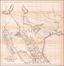
Early Geological Map of the Dakotas and Nebraska including Cretaceous Oil-Bearing Rocks
A large format map of Kansas, Nebraska, Dakota and part Colorado and Wyoming, extending as far southeast as Denver, Colorado City and St. Vrains showing the geology of this area.
The map includes excellent detail of railroads including the Union Pacific, showing two parallel routes: one ending in Denver and the other a little to the north heading into Wyoming. Dozens of forts are located on this map. Numerous routes of explorations and surveys are drawn in. This includes Captain Raynolds's 1859 expedition to the Yellowstone and Nicollet's 1839 expedition mapping the upper Mississippi. Areas roamed by the principal American Indian tribes are shown. Warren's extensive knowledge of the area and his skill as a cartographer are obvious in this large, detail-filled map.
Geological Interpretation
The map shows eight geological formations ranging from granites and metamorphics [pre-Cambrian] to Paleocene fluvial sediments. This is likely the earliest map to show the oil-bearing Cretaceous sandstones of North Dakota in any detail. The two dominant structures in the map are a bullseye pattern in South Dakota and a north-south anticline in Colorado. This latter appears to be a complete guess at the geology of the Rocky Mountains, though the former observation has some merit.
One of the geological formations shown is the Potsdam Sandstone. The type locality for this building stone is in New York and extends into parts of nearby states and provinces. It unconformably overlays Proterozoic rocks. In 19th century geology, this name was given to any North American sandstone that unconformably overlaid Precambrian metamorphic rocks. Units such as these are common in North America, and typically referred to as part of the "Great Unconformity," a topic of current debate.
In this map, the Potsdam Sandstone overlays the granites of the Black Hills. Uplifted during the Laramide orogeny, they are now the core of the Black Hills, containing Black Elk Peak (the highest point in the state) and Mount Rushmore. These granites were formed during the Trans-Hudson Orogen in the Neoarchean. This map shows the Potsdam unit at the core of the bullseye, and not granites. Modern maps and logic appear to suggest otherwise, so whether this was a misinterpretation, a misprint, or something else entirely remains to be seen.
The geology was provided by Dr. Ferdinand Hayden, then Professor of Geology and Mineralogy at the University of Pennsylvania. This was surveyed only 4 years prior to his famous trip of exploration into Yellowstone that resulted in Yellowstone becoming the first National Park in the United States. The map accompanied Hayden's Final Report of the United States Geological Survey of Nebraska and Portions of the Adjacent Territories, (42d Congress 1St Session House of Representatives Ex. Doc. No. 19), published in 1872.
This geological survey was conducted with excess funds which remained from the establishment of the Nebraska legislature. The geologist was instructed to pay particular attention to possible building stones (of which the Potsdam was a possibility), soils, ores, elevations in mountainous areas and more. Conducted in the year of Nebraska's statehood, this survey is an exemplary study in late 19th-century geology.
The Black Hills Gold Rush would follow less than 10 years after the map was made.
States of the Map
The various states and editions of the map are identifiable as follows:
- State 1. Two column list of explorations and surveys. No information included from after 1858.
- State 2. Bien imprint at bottom left and revised list of explorations and surveys, with the last line (Nicollet) centered.
- State 3. Colored to show Geological information. Bien imprint removed, exploration and survey tables removed, new title info and geological table added.
- Second Edition: An entirely new set of stones. List of explorers and surveys re-added, but last line is left justified. No Bien imprint and the line of the Union Pacific is now completed and shows a track pattern. The map depicts updated railway information from at least as late as 1870, most notably, the Kansas City to Denver line of the Union Pacific Railway, which was only completed that year. An updated edition of Hayden's geological version of the Warren map was also produced on the heals of the second edition.
- Third Edition: Issued in 1875. Following the discovery of gold in the Black Hills in 1874, interest in the region intensified. In response, the federal government issued G.K. Warren's Preliminary Report of Explorations in Nebraska and Dakota, in the Years 1855-56-57 (Washington, 1875), which contained the fourth edition of the map. The report was issued in 2,000 copies, ensuring that the fourth edition is today easily obtainable.
This is the third state of Gouverneur Kemble Warren's large format map. Warren's extensive knowledge of the area and his great skills as a cartographer are obvious in this large, highly detailed map. An excellent example of this remarkable map, which rarely appears on the market.
Ferdinand Vandeveer Hayden, known to the Sioux as "man-who-picks-up-stones-running," stands among the pantheon of eminent geologists of the 19th century.
Hayden's academic career commenced at Oberlin College, and he furthered his education at Albany Medical College, where he received his M.D. in 1853. Despite his medical training, Hayden was primarily engaged in geology, a field to which he would dedicate his life's work.
Hayden commenced his geological career with a survey in the Nebraska Territory in 1856. In 1859 and 1860, he conducted further exploratory work in the Rocky Mountains, particularly in Colorado, which was then part of the Nebraska and Kansas territories. His early work in the field earned him the respect of Native American tribes, with the Sioux reportedly dubbing him "man-who-picks-up-stones-running" due to his avid and energetic collection of geological samples during his expeditions.
By the 1860s, Hayden had risen to prominence as a geologist and was appointed the United States Geologist for the Geological Survey of the Territories. This role would define his career, leading numerous surveys in the Western United States. Notably, from 1871 to 1872, Hayden led a survey into the region that would become Yellowstone National Park, and his reports significantly contributed to the establishment of Yellowstone as the first National Park in 1872.
Hayden's most significant contribution to geological literature was the Geological Atlas of Colorado, published in 1877. This work was the result of comprehensive surveys conducted across Colorado, meticulously documenting the state's geography and geology. The atlas offered detailed maps on a scale previously unseen, encompassing not only Colorado but adjacent areas, including parts of Utah, Arizona, and New Mexico.
Hayden's influence extended to academia, as he was affiliated with the University of Pennsylvania for a period, where he held the position of professor of geology. His academic and field work combined to form a substantial body of knowledge that would be used by future scholars and explorers.
Ferdinand V. Hayden passed away on December 22, 1887, in Philadelphia, Pennsylvania. His enduring legacy is reflected in the numerous natural features named after him, including Hayden Valley in Yellowstone and Mount Hayden in Colorado. His contributions to geology during the 19th century remain a cornerstone of American geological and geographical sciences.

![[Report and] Map of an Exploring Expedition to The Rocky Mountains in the Years 1842 and to Oregon & North California in the Years 1843-44 By Brevet Capt. J. C. Fremont of the Corps of Topographical Engineers . . .](https://storage.googleapis.com/raremaps/img/small/88488.jpg)
![(North Dakota) Scalp Dance of the Minatarres [near Fort Clark, on the Missouri River]](https://storage.googleapis.com/raremaps/img/small/77692.jpg)