|
||

|

|
|

|
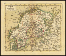
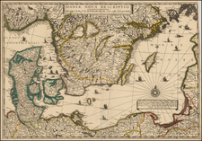
Highly decorative map of Sweden, stretching from the North Sea to Lapland and the Baltic. This map was first published in London by Emanuel Bowen in the mid-18th century for his A Complete System of Geography.
The map is highly detailed and names many provinces and more. The map shows towns, mountains, rivers, islands, roads, and other details. A decorative vignette appears in the lower right.
This map shows the Scandinavian Peninsula after the end of the Great Northern War, which saw pan-European conflict. In the Scandinavian field, Russian and Swedish troops fought extensively over Finland. At the end of the war, it came under Swedish dominion, establishing that country's importance as a leading European power. A note in the upper right states refers to a 1743 treaty that ended the Russo-Swedish War, in which Sweden ceded back a small amount of territory.
Bowen based his map on van Keulen's Baltic charts.
Emanuel Bowen (1694?-1767) was a British engraver and print seller. He was most well-known for his atlases and county maps. Although he died in poverty, he was widely acknowledged for his expertise and was appointed as mapmaker to both George II of England and Louis XV of France. His business was carried on by his son, Thomas Bowen. He also trained many apprentices, two of whom became prominent mapmakers, Thomas Kitchin and Thomas Jeffreys.