|
||

|

|
|

|
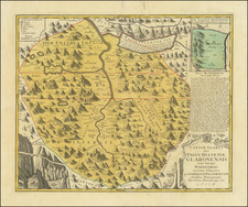
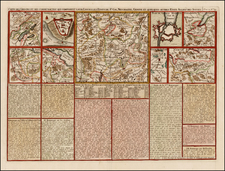
A Fine and Uncommon Map of Basel Based on 17th-Century Manuscripts
Highly decorative map of the region around Basel, Switzerland, showing the region of its Canton as well as parts of Germany and France. Surrounding the map are a number of views of cities and important towns. This map was published in 1729, likely in Basel, by Christopher Brunner.
This map was based on the large-scale manuscript maps of the region around Basel created by Georg Fredrich Meyer between 1680 and 1690. Daniel Bruckner, in his 1766 Canton Basel, would also reuse these same maps. We are unable to find any record of Brunner making any additional maps during his lifetime, as Swiss cartobibliographies only list the presented map.
The map is highly detailed, showing cities, towns, fortifications, rivers, forests, and more. The coats of arms of several Swiss cantons are shown, including those of Bern, Basel, and Zug. The views shown around the map include a tiny archeological site credited to Augusta Raurocorum, a Roman colonizer of Switzerland, various castles, and the cities of Liechtstal, Basel, and Wallenburg. A key provides the locations for places of interest in these larger cities.
Bibliographie der Schweizerischen Landeskunde. Page 96.
![[Lake Neuchâtel]](https://storage.googleapis.com/raremaps/img/small/73670.jpg)