|
||

|

|
|

|
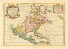
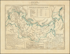
Antique Map of North America – Showing Mythical Bay of the West!
Fine example of the last edition of Janvier's map of North America to illustrate the intriguing Sea of the West, prior to the incorporation of information from Cook's voyages.
In this late edition, the earlier plate has been changed to delete the words “du Roy” from the publication privilege.
The interior of North America is split into the United States, Canada, Louisiana, and Spanish holdings. The western reaches are peppered with numerous Indigenous names and early French forts. Iceland is marked as a possession of Denmark.
Greenland appears connected to the continent north of Baffin Bay. Also far north, but to the west, the Alaskan peninsula is tentatively theorized based on reports of Vitus Behring’s crews (here “Beering”) on their First and Second Kamchatka Expeditions (1728-30, 1733-43).
Sea of the West
Whereas the inclusion of the United States is up to date, other inclusions on the map were less common by the 1770s. The feature that most attracts the attention of the modern viewer is the Mer ou Baye de l’Ouest in the interior of North America. The Sea of the West, which had first appeared on charts published by Johann Baptiste Nolin in ca. 1700, had quickly disappeared thereafter. However, in 1752, Philippe Buache and Joseph Nicholas De L’Isle, Guillaume’s son-in-law and brother respectively, included the sea on their controversial map highlighting the recent discoveries by the Russians in the far northern Pacific. While a few other mapmakers adopted and modified the feature, it was not common on maps of the 1770s and 1780s.
The re-introduction of the sea was the result of Buache’s review of his father-in-law’s papers. Although Guillaume De L’Isle never published a map showing the sea, he had postulated that it could exist, and that it might connect to a Northwest Passage through New France, not through English territory farther north. Nolin had plagiarized the idea from Guillaume, as the latter testified when suing the former for plagiarism. He said, the Sea of the West “was one of my discoveries. But since it is not always appropriate to publish what one knows or what one thinks one knows, I have not had this sea engraved on the works that I made public, not wanting foreigners to profit from this discovery” (as quoted in Pedley, 109).
The Russian discoveries in the Pacific Northwest and the odd case of Stitchan Nitada
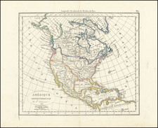
The sea between North America and Russia is now filled with islands and labels. These originate from, as the map states, “Découvertes par les Russes depuis 1740,” or discoveries made by the Russian by 1740.
Two expeditions led by Vitus Behring (1728-30, 1733-43) explored Kamchatka and what is now Alaska, charting the strait between them. The first maps of the discoveries appeared in France in the early 1750s, followed by a German map by Gerhard Müller, a member of the second Kamchatka Expedition, first published in 1754 and distributed more widely in a 1758 edition. These maps, though they differed in many respects, show the strait between the continents and the westward thrust of the Alaskan mainland/archipelago.
In the 1760s, Russian fur traders discovered more and more of the Aleutian Islands, some of which are shown here. In 1764, another Second Kamchatka Expedition veteran, Lieutenant Ivan Synd, led a new voyage to the Bering Sea. He was in search of the Northwest Passage, but also hoped to clarify to what extent western Alaska was a peninsula or an archipelago. He produced several maps, all but one of which have been lost. The map that does survive shows a series of islands nearly touching Kamchatka, not a peninsula.
As a result of Synd’s findings, a modified 1773 Russian edition of Müller’s chart converts Müller’s large peninsula to a string of islands. In the same year Jacob von Stählin, secretary to the Russian Academy of Sciences, created his own map based on Synd’s discoveries entitled, “A Map of the New Northern Archipelago discover’d by the Russians.” This map, published in a book with a similar title, was a source for this 1774 edition of Covens & Mortier’s map of the Americas. Although it does not copy Stählin’s map exactly—it does not include a large Alaschka Island, for example—the Covens & Mortier map does adopt several toponyms from the Stählin map, including Stachtan Nitada on the North American mainland, near the Arctic Circle.
Written as Satchan Nitada on the Covens & Mortier example, this toponym seems to have been included for the first time by Stählin. It is supposedly a place Synd landed at and is near the sighting of the Alaskan mainland by the Russians in 1730, an event also marked on this map. The book excited members of the Royal Society of London, who ensured that the German language publication was translated into English by the end of 1774.
However, Stachtan Nitada’s precise location and importance remained unclear to explorers, none more so than James Cook. Cook carried the English translation of Stählin’s map with him on this third voyage, which was focused on finding the Northwest Passage. What interested Cook was the strait between Stachtan Nitada and the nearest island to the west, a feature repeated, in reduced form, on this map. It seemed to Cook and others planning his third voyage that this could be an entrance to a Northwest Passage.
When Cook arrived in search of the islands and passage in 1778, he found no such place. As J.C. Beaglehole, Cook’s twentieth-century editor, explains:
…no one could be too hard on Stählin. He had thrown the name Alaska on to an arbitrary island in the north; the other name Stachtan Nitada was unknown to either Russian or Aleut…As a cartographer he was naïve, even infantile; and he was unwise enough to speak slightingly of seamen. (Journals of Captain Cook, cxxxvii-cxxxviii)
Cook himself had choice words about Stählin and Stachtan Nitada. In his journal of October 1778, he wrote:
Stachtan Nitada as it is calld in the Modern maps, is a name quite unknown to these people, Indians as well as Russians, but both know it by the name of America. (251)
Of Stählin’s map, Cook wrote later in October 1778:
If Mr Stehlin was not greatly imposed upon what could induce him to publish so erroneous a Map? in which many of these islands are jumbled in in [sic] regular confusion, without the least regard to truth and yet he is pleased to call it a very accurate little Map? A Map that the most illiterate Seafaring men would have been ashamed to put his name to. (456)
Cook would not test Stählin’s hypotheses until late in the 1770s, and this state of the map does not incorporate the information from his third voyage (1776-1780). For that reason, Stachtan Nitada appears here and on several other contemporary maps and is an enduring example of the conjectural nature of mapmaking.
Many European maps of North America in the eighteenth century depict a large, western inland sea, hundreds of miles in diameter, with a small inlet to the Pacific and even some interior islands. The origins of this myth can be traced to several different sources and are tied to the search for a Northwest Passage. Like many cartographic myths, the Sea of the West persisted for decades, even in the face of strong evidence pointing to its non-existence.
One of the first European navigators to supposedly explore this area was Martin Aguilar. A Spanish captain, he sailed with Sebastian Vizcaino on a reconnaissance expedition up the California coast in 1602-3. Aguilar, commanding the Tres Reyes, was blown off course, to the north. When the seas calmed, Aguilar reported that he had found the mouth of a large river. Eighteenth-century geographers later conjectured that the river was the entrance to the Sea of the West.
Other maps placed the entrance to the Sea of the West via the Juan de Fuca Strait. Juan de la Fuca is the Castilianized name of Greek navigator Ioánnis Fokás (Phokás). Little archival evidence survives of Fuca’s career, but a chance meeting with an English financier, Michael Lok, in Venice in 1596 gave birth to rumors of Fuca’s voyages in the Pacific. Fuca reported that he had been sent north from New Spain twice in 1592 in search of the Strait of Anian. The Spanish Crown failed to reward Fuca’s discovery of an opening in the coast at roughly 47° N latitude and Fuca left the Spanish service embittered. His story lived on in Lok’s letters and eventually was published in Samuel Purchas’ travel collection of 1625. On many eighteenth-century maps, Fuca’s Strait is linked with a River or Sea of the West. In 1787, the present-day Juan de Fuca Strait was named by the wife of naval explorer Charles William Barkley, making permanent a label that had previously just been hopeful guesswork.
The source of the modern (18th Century) myth of the Sea or Bay of the West (Baye ou Mer de L'Ouest in French), are manuscript maps by Guillaume De L'Isle, who served as the Royal Geographer to the King of France at the end of the 17th Century and beginning of the 18th Century and is widely regarded as the most important map maker of his time. There is a map in Yale's map collection, which depicts a 16th Century Thames school map of North America with a large, "Branch of the South Sea," which closely resembles De L'Isle's Mer de L'Ouest, and may well be the source of De L'Isle's idea.
At the end of the 17th Century, Guillaume De L'Isle had access to the best available maps of the interior of North America, which were being provided from a number of missionary sources, as the French Missionaries pushed west of the Great Lakes and the Mississippi River and obtained information from the indigenous Indian tribes. De L'Isle was regularly producing and updating his manuscript maps in an attempt to integrate new and often conflicting information and improve upon the existing maps of North America. Many of his maps can be viewed as drafts, which were discarded in favor of other and considerably different models.
There are several De L'Isle manuscripts in the Bibliotheque Nationale de France, prepared as early as 1696 (dated), that depict this cartographic myth. Interestingly, while De L'Isle was a prolific publisher of printed maps, he never depicted the Sea or Bay of the West on any of his printed maps, which strongly suggests that he was not able to reconcile this information with the best available source information from America. During this same period, Jean Baptiste Nolin, who had in the prior decade collaborated with Vincenzo Maria Coronelli on his monumental globe for Louis XIV and produced a series of highly important maps of North America and its regions, would have also had access to many of the same reports and maps as De L'Isle. Nolin apparently gave greater credence to the concept than De L'Isle.
The earliest printed map to show the Bay of the West is Jean Baptiste Nolin's rare wall map of the world, published in about 1700. Nolin plagiarized the idea from Guillaume De L'Isle, as he testified when suing Nolin for plagiarism. He said, the Sea of the West “was one of my discoveries. But since it is not always appropriate to publish what one knows or what one thinks one knows, I have not had this sea engraved on the works that I made public, not wanting foreigners to profit from this discovery” (as quoted in Pedley, The Commerce of Cartography, 109). The court sided with De L'Isle and issued an order requiring Nolin to destroy the copper plates for the map (see Shirley 605). Nolin's map was in turn copied by the Mortier family, who issued 3 world maps shortly thereafter, showing Nolin's version of the Sea of the West, but the myth ignored for nearly half a century.
While the myth of the Sea or Bay of the West temporarily languished, the proliferation of Russian exploration off the Northwest Coast of America after 1740, as reported by Guillaume's younger brother Joseph Nicholas De L'Isle, reinvigorated interest in the region and forced the most prominent map makers of the period to re-examine existing knowledge. Joseph Nicolas served as a geographer to the Russian Academy and returned with this information to Paris. The re-introduction of the sea in the mid-eighteenth century was the result of Guillaume De L’Isle’s son-in-law, Philippe Buache’s review of his father-in-law’s papers. Although Guilluame De L’Isle never published a printed map showing the sea, he had postulated that it could exist, and that it might connect to a Northwest Passage through New France, not through English territory farther north.
The sea was a major part of Buache and Joseph-Nicholas Delisle’s maps of the North Pacific, published in the 1750s. While controversial, the features of those maps were quickly copied by other mapmakers, including the Sea of the West. The inland body of water lingered on maps until the later-eighteenth century.
During a period between 1750 and 1770, the most prominent French and British map makers advanced multiple and widely varying theories on the Northwest Coast of America. Denis Diderot dedicates several of the 10 maps in his monumental Encylopedie (1779 and after), to a comprehensive survey of the maps proffered by Joseph Nicholas De L'Isle (Guillaume's brother), Philippe Buache, Thomas Jefferys and others. The debate ended with Captain James Cook's and later George Vancouver and Comte Jean de la Perouse's explorations in the late 18th Century.
![[Alaska to San Diego and San Qunitin, British Columbia] A Chart Shewing Part of the Coast of N.W. America, with the Tracks of His Majesty's Sloop Discovery and Armed Tender Chatham . . . (First Modern Map of the West Coast of North America)](https://storage.googleapis.com/raremaps/img/small/102067.jpg)