|
||

|

|
|

|
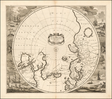
Owned by Francis Davies a Member of the British Antarctic Expedition.
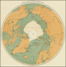
Impressive and very rare British Admiralty chart of Antarctica and the South Pole. The chart was first issued in London in 1887 but here has updates to October 9, 1914.
This was the most advanced commercially available chart of the continent when the great era of Antarctic exploration was underway. The map shows the scant confirmed coastline of Antarctica, with large blank areas where the outline had yet to be determined. Soundings in the far Southern Ocean are sometimes included in places where land had not been reached. Most of the cartographical activity of the map is focused on the Ross Sea and the marine route to the South Pole, noting Amundsen, Scott, and Shackleton's routes. Amundsen's arrival at the South Pole is recorded as "Amundsen 14th to 17th December 1911", while Scott's says "18th Jan. 1912". Various other explorers' discoveries and dates of discovery are scattered around the continent.
The map captures the sense of the extreme unknown faced by explorers heading south at this time and the very fragile nature of their endeavors.
The magnetic South Pole and related isogons are shown on the chart.
Rarity
OCLC records three institutional examples of the chart: British Library, Newberry Library, and the University of Wisconsin, Milwaukee (presumably AGS).
Provenance
‘Terra Nova’ Expedition archive material of Francis Edward Charles Davies.
Davies was the shipwright for the Terra Nova expedition from 1910-1913, serving under the expedition leader Robert Falcon Scott. As part of his responsibilities, Davies outfitted the expedition ship Terra Nova and designed and built the prefab winter quarters to be used on Antarctica. Davies was part of the rescue party that went in search of Scott, and because of his carpentry skills, he constructed the memorial cross over the cairn that held the bodies of Scott, Henry Robertson Bowers, and Edward Adrian Wilson. Apparently, Davies gave lectures on the British Antarctic Expedition, and it was perhaps for this purpose that he acquired the present chart.
The British Admiralty has produced nautical charts since 1795 under the auspices of the United Kingdom Hydrographic Office (HO). Its main task was to provide the Royal Navy with navigational products and service, but since 1821 it has also sold charts to the public.
In 1795, King George III appointed Alexander Dalrymple, a pedantic geographer, to consolidate, catalogue, and improve the Royal Navy’s charts. He produced the first chart as the Hydrographer to the Admiralty in 1802. Dalrymple, known for his sticky personality, served until his death in 1808, when he was succeeded by Captain Thomas Hurd. The HO has been run by naval officers ever since.
Hurd professionalized the office and increased its efficiency. He was succeeded by the Arctic explorer Captain William Parry in 1823. By 1825, the HO was offering over seven hundred charts and views for sale. Under Parry, the HO also began to participate in exploratory expeditions. The first was a joint French-Spanish-British trip to the South Atlantic, a voyage organized in part by the Royal Society of London.
In 1829, Rear-Admiral Sir Francis Beaufort was appointed Hydrographer Royal. Under his management, the HO introduced the wind force scale named for him, as well as began issuing official tide tables (1833). It was under Beaufort that HMS Beagle completed several surveying missions, including its most famous voyage commanded by Captain FitzRoy with Charles Darwin onboard. When Beaufort retired in 1855, the HO had nearly two thousand charts in its catalog.
Later in the nineteenth century, the HO supported the Challenger expedition, which is credited with helping to found the discipline of oceanography. The HO participated in the International Meridian Conference which decided on the Greenwich Meridian as the Prime Meridian. Regulation and standardization of oceanic and navigational measures continued into the twentieth century, with the HO participating at the first International Hydrographic Organization meeting in 1921.
During World War II, the HO chart making facility moved to Taunton, the first purpose-built building it ever inhabited. In 1953, the first purpose-built survey ship went to sea, the HMS Vidal. Today, there is an entire class of survey vessels that make up the Royal Navy’s Hydrographic Squadron. The HO began to computerize their charts in the late 1960s and early 1970s. In 1968, the compilation staff also came to Taunton, and the HO continues to work from there today.