


|
||

|

|
|

|
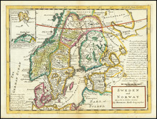
Detailed original antique map by Herman Moll of the Baltic and contiguous regions, extending from the St. Petersburg area to the Gulf of Bothnia, Norway and Denmark. The map is particularly interesting for its early depictions of roads, which connect major cities and cross the Baltic between Pomerania and Sweden. The map was published by Moll in London in the first part of the 18th century.
In addition to these roads, many cities, towns, and more are all shown. Berlin, Hamburg, Copenhagen, Stockholm, Anslo (Oslo), and Warsaw are all shown. Curiously, St. Petersburg does not appear yet despite its 1703 founding, but the boundaries shown are correct following the conclusion of the Great Northern War (which ended in 1721). Sweden controls most of Finland, while Norway is part of Denmark.
The map is decorative yet simple, showing Moll's classic style. An inset shows the passage between the Danish islands of Zeeland and Schonen, and includes numerous depth soundings that would have been of use to ship captains. In all, a very nice map.
Herman Moll (c. 1654-1732) was one of the most important London mapmakers in the first half of the eighteenth century. Moll was probably born in Bremen, Germany, around 1654. He moved to London to escape the Scanian Wars. His earliest work was as an engraver for Moses Pitt on the production of the English Atlas, a failed work which landed Pitt in debtor's prison. Moll also engraved for Sir Jonas Moore, Grenville Collins, John Adair, and the Seller & Price firm. He published his first original maps in the early 1680s and had set up his own shop by the 1690s.
Moll's work quickly helped him become a member of a group which congregated at Jonathan's Coffee House at Number 20 Exchange Alley, Cornhill, where speculators met to trade stock. Moll's circle included the scientist Robert Hooke, the archaeologist William Stuckley, the authors Jonathan Swift and Daniel Defoe, and the intellectually-gifted pirates William Dampier, Woodes Rogers and William Hacke. From these contacts, Moll gained a great deal of privileged information that was included in his maps.
Over the course of his career, he published dozens of geographies, atlases, and histories, not to mention numerous sheet maps. His most famous works are Atlas Geographus, a monthly magazine that ran from 1708 to 1717, and The World Described (1715-54). He also frequently made maps for books, including those of Dampier’s publications and Swift’s Gulliver’s Travels. Moll died in 1732. It is likely that his plates passed to another contemporary, Thomas Bowles, after this death.
![[Fyn / Odense / Denmark] Pascaarte van't Zuijderdeel vande Belt](https://storage.googleapis.com/raremaps/img/small/75607.jpg)
![[Latvia & Estonia] Livonia](https://storage.googleapis.com/raremaps/img/small/69198.jpg)

![[ Ethnographic Thematic Atlas - Poland, Lithuania, Ukraine, etc. ] Völker-Verteilung in West-Russland (Distribution of Peoples in Western-Russia)](https://storage.googleapis.com/raremaps/img/small/94045.jpg)