


|
||

|

|
|

|
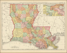
Louisiana Two Years After Statehood and on the Eve of the Battle of New Orleans
A fine example of Mathew Carey's map of Louisiana, one of the earliest large format maps of the state to appear in a commercial atlas.
This is one of the earliest obtainable maps of Louisiana following its becoming a state, published just two years after Louisiana became a state on April 30, 1812.
Includes roads, towns, rivers, lakes, and a host of other details. The southwestern part of the State is still largely unexplored, with virtually no information west of the Sabine River, other than the Carcusia (Calcasieu) River, flowing into a primitive depiction of Calcasieu Lake, with no hint of Lake Charles to the North.
A bit further west, on the coast, "Impassable Swamps" provides an editorial commentary on access to the region by water.
Remarkable early detail, only 10 years after admission to the United States.

![[ Mississippi River Atlas ] Theorie der Bewegung des Wassers in Flüssen und Canälen. . . . (Atlas Volume)](https://storage.googleapis.com/raremaps/img/small/101700.jpg)
