The item illustrated and described below is sold, but we
have another example in stock. To view the example which
is currently being offered for sale, click the
"View Details" button below.


|
||

|

|
|

|
Stock# 79718
Description
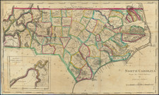
Eartly Map of North Carolina
Striking example of the edition of Mathew Carey's map of North Carolina, one of the earliest large format maps of the State after independence.
Includes the topography of North Carolina, as well as roads, towns, rivers, lakes, and a host of other details.
The map shows the growth of the State in the early 19th Century. Meticulous details shown to the inclusion of the growing road system in the State Court houses, in each county, are noted, as are the major towns.
Mathew Carey issued his first folio atlas map of North Carolina in 1795. A second edition of the map was issued in 1814 and a third edition also issued in 1814. The editions can be identified as follows (year in parenthesis is first year published)
- 1st Edition / State 1 (1795): The State of North Carolina from the best Authorities by Samuel Lewis.
- 1st Edition / State 2 (1800): Page #37 added
- 2nd Edition / State 1 (1814): New plate. North Carolina. Title in swath letters. No County Borders Shown
- 2nd Edition / State 2 (1814): County Borders Added
- 3rd Edition / State 1 (1814-1816): New plate. North Carolina from the Latest Surveys by Samuel Lewis. Title in block letters. Anson and Rutherford counties shown, but unnamed. Craven County spelled C R A W E N.
- 3rd Edition / State 2 (1817-1818): Anson and Rutherford counties named; Craven County now correctly spelled