|
||

|

|
|

|
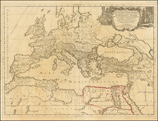
Fine original antique political map of Europe, showing continent with its approximate borders. The map was published in Paris by Nicholas de Fer in 1705.
The map includes a number of features of interest. Sweden extends into what is now Finland and Russia. Tsar Peter I is not yet shown to have captured Nyenskans and renamed it St. Petersburg, although he had done so two years prior, in 1703, as part of the Great Northern War. Greece and the Balkans are shown as part of "Turkey in Europe."
A number of cities are shown, with important cities shown using a small pictorial symbol. The Alps, Pyrenees, and Carpathians are shown pictorially. Rivers are also shown. In all, a very nice antique map.
Nicholas de Fer (1646-1720) was the son of a map seller, Antoine de Fer, and grew to be one of the most well-known mapmakers in France in the seventeenth century. He was apprenticed at twelve years old to Louis Spirinx, an engraver. When his father died in 1673, Nicholas helped his mother run the business until 1687, when he became the sole proprietor.
His earliest known work is a map of the Canal of Languedoc in 1669, while some of his earliest engravings are in the revised edition of Methode pour Apprendre Facilement la Geographie (1685). In 1697, he published his first world atlas. Perhaps his most famous map is his wall map of America, published in 1698, with its celebrated beaver scene (engraved by Hendrick van Loon, designed by Nicolas Guerard). After his death in 1720, the business passed to his sons-in-law, Guillaume Danet and Jacques-Francois Benard.
![(Data Visualization - Table of Distances) Germaniae Aliorumque Quorundam Locorum Europae Poliometria | Richtige Anzeige wei weit die Haupt-Orte in Deutschland und andere berühmte Staedte in Europa von einander entlegen, heraus gegeben von Tobias Conrad Lotter Geogr. in Augsburg. [Polymetry of Germany and Some Other Places in Europe | Accurate display of how far the main locations in Germany and other famous cities in Europe are from each other, published by Tobias Conrad Lotter, Geographer in Augsburg.]](https://storage.googleapis.com/raremaps/img/small/97280.jpg)
![[Course of the Rhine River] Corso del Reno Parte Septentrio [and] Corso del Reno Parte Meridionale . . . 1690](https://storage.googleapis.com/raremaps/img/small/73095.jpg)
![[ European Cooperation ] Organisation Europeenne de Cooperation Economique](https://storage.googleapis.com/raremaps/img/small/78837.jpg)