|
||

|

|
|

|
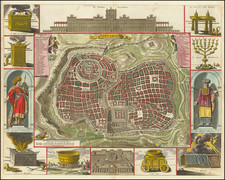
Jerusalem at Partition, as Annotated by the French Consulate
Finely-detailed map of Jerusalem and its environs, made by the Survey of Palestine in 1947, the year of the Partition of Palestine.
The map is extensively annotated in ink, with the flag of France at the center of the map (letter A) near the King David Hotel. This is the location of the French Consulate (established in 1948) and it appears the annotations were added by the French Consulate’s office.
Prepared at 1:10,000 scale, the map shows the city and its surrounding lands in exhaustive detail. It locates many points of interest, including mosques, synagogues, churches, cinemas, schools, football grounds, tombs, antiquities, cable and telegraph lines, and railways. It also shows the important holy places of Judaism, Islam, and Christianity.
The annotations denote the location of the French Consulate. They highlight in orange prominent buildings such as monasteries, hospitals, orphanages, and the Tomb of the Kings. They also denote sections of the city extending to its outskirts.
The British Mandate and Partition of Palestine
Palestine was placed until British control in 1918; the League of Nations approved of the Mandate in 1922. The new Mandate adopted the Balfour Declaration of 1917, which declared that a Jewish home state should be created in Palestine.
The Mandate lasted until 1948. It witnessed large-scale Jewish immigration, particularly once the Nazis came to power in the 1930s. After the end of the World War II, and in the wake of the devastation of the Holocaust, the question of a Jewish home state was turned over to the newly-minted United Nations.
With Resolution 181 (II), in 1947, the UN decided to end the Mandate and make Palestine into two independent states: one Jewish and one Arab. Under this plan, Jerusalem was to be an international city. However, Israel declared its independence and, during the 1948 Arab-Israeli War, Israel seized land designated for the Palestinian state, ultimately occupying 77% of the former Mandate. During this time, over half of the Palestinian population was expelled or fled.
The conflict was not limited to Arab-Israeli involvement. French diplomats and Zionist groups had long shared clandestine information via their secret services. France supported the Zionist cause for a variety of reasons, not least because they wanted the British rule to end as their own had in Syria and Lebanon. Indeed, they were caught up in the Altalena affair of June 1948—where interim prime minister David Ben-Gurion’s Israel Defense Forces sunk a boat owned by Irgun Zvai Leumi (Etzel), a rival political group—as they supplied the ship with weapons and ammunition. Etzel had previously attacked British targets in Palestine and Europe, including the King David Hotel, shown near the French Consulate on this map, in 1946.
As a result of the conflict, the UN General Assembly passed Resolution 194 (III) on December 11, 1948. It established a three-member Conciliation Commission for Palestine. The Commission would be headquartered in Jerusalem and made up of delegates from France, Turkey, and the United States. They were supposed to oversee the repatriation of refugees, or their compensation if they decided not to return. At this time, the General Assembly resolved that the city should be placed under UN control and suggested that new solutions needed to be found for access to holy sites. The Commission was active until 1952, when it declared it was unable to fulfill its duties.
This map, with annotations highlighting the French Consulate, was likely made by the Consulate or their staff. It was possibly annotated in reference to the Conciliation Commission, as the buildings highlighted are places where refugees could be directed.
The Survey of Palestine and the mapping of Jerusalem
The British initially mapped Palestine in the first half of the nineteenth century. In the 1840s, the Admiralty ordered a coastal survey and one of the continental shelf, while the Royal Engineers mapped the towns and the interior. Both the German and the British armies carried out further surveys during World War One.
With regard to Jerusalem, the German explorer F. W. Sieber made a map of the city with 200 geometric control points in 1818. F. Catherwood, an English architect, made an important panorama of the city in 1833. In 1841, Royal Engineers Lieutenants J.F.A. Symonds and E. Aldrich mapped the city with an emphasis on points of military interest. Their work was improved upon by Lieutenant C.M.W. van de Velde, a Dutch naval officer. Finally, Captain Charles Wilson and his men from the Ordnance Survey mapped Jerusalem in 1864-5. Their work led to the creation of the Palestine Exploration Fund, who led expeditions to excavate and map Jerusalem and other holy sites.
Upon being assigned the Mandate, in 1920, Britain established a new office to map the area from scratch. They did so, “to survey and map the lands of the country as demanded by the Zionist Organization, in order to implement legally binding land settlement and registration of tenure rights” (Gavish, xiv). While the Land Settlement Department struggled and had to be re-organized, the Survey Department proved adept at geodetic surveying, cadastral mapping, and topographic mapping. It was eventually folded into the state of Israel in 1948.
One of the first projects of the Survey Department, begun in 1920, was to make a new map of Jerusalem outside the Old City Walls. They completed the survey in July 1922. The surveyors completed a draft map in September of that year, when it was initially printed. More area was added, until the map was comprised of forty-six sheets in 1925. This map was made at a scale of 1:2,000. Happy with the results, it was sent to the Ordnance Survey in Southampton, where it was reduced to a single-sheet of 1:10,000. In 1945, the Survey of Palestine reissued the map in one and six sheets. This is an updated version (1947) of the one sheet map made as the Mandate was drawing to a close.
![(Jerusalem - Temple of Salomon) Templum Salomonis [with Perugia on verso]](https://storage.googleapis.com/raremaps/img/small/96662.jpg)
![[Jerusalem] Prospectus Sanctae olim et celeberrimae Urbis Hierosolymae . . . / Prospect der vormals Heiligen und Welt Berühmtem Stadt Jerusalem . . .](https://storage.googleapis.com/raremaps/img/small/84909.jpg)