
Rare Facsimile of a Foundational Document in American History
Rare 19th Century reprint of William Penn's extremely famous and exceedingly rare work, describing the planning and foundation of Philadelphia, and listing the names of the original settlers, etc.
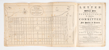
The work includes an early facsimile copy of Thomas Holme's A Portraiture of the City of Philadelphia… (1683), the first printed map of the city and the earliest design for a planned community in America. The map accompanies William Penn's letter explaining and promoting his new colony to prospective investors and settlers. It also includes the original Advertisement... by Thomas Holme, Penn's official surveyor, explaining his map of Philadelphia. The pair form a critical primary document relating to the foundation of Pennsylvania, and one of the most important 17th Century imprints relating to America.
The map is a detailed master plan for the future city of Philadelphia, the site of which was selected in 1682 as the capital of Pennsylvania. The design was conceived by Thomas Holme, the first Surveyor General of Pennsylvania, and a close confidant of William Penn. As shown on the map, the city was planned to be laid out on a 12,000-acre rectangular tract (approximately 1 mile wide and 2 miles long) bisecting a peninsula that lay between the Delaware and Schuylkill Rivers. On these lands the new city was constructed along a rectangular grid of wide streets, featuring five large public squares.
While Holme's plan was made prior to the city's construction, the realized street plan of the city came to closely follow his design, which is still evident to this day. The main east-west artery was to be called High Street (today's Market Street) and the main north-south thoroughfare was to be named Broad Street. These two main arteries were to be 100 feet wide, while all other streets were to be 50 feet wide, generally much wider than the streets in comparable towns (such as New York, Boston and London). The five public squares were named Centre Square (later the site of City Hall), Northeast Square (today's Franklin Square), Northwest Square (Logan Square), Southwest Square (Rittenhouse Square), and Southeast Square (Washington Square). The map includes the outlines of the cadastral lots, identified by numbers, which had already been granted or sold to proprietors, including 149 lots fronting the Delaware River, 43 lots fronting the Schuylkill River and 192 street lots in the interior. The lot numbers correspond to a list of proprietors that originally accompanied the map. A small ovoid inset located in the bottom center of the map is inhabited by general perspective of the city's location on the peninsula between the Delaware and Schuylkill Rivers. The rivers themselves are adorned with sailing ships and their banks feature stylized illustrations of flora, lending the composition a pleasant disposition.
Notably, Holme's map was engraved by John Thornton (1741-1708), one of the greatest English mapmakers of the era, being the official cartographer to the Hudson's Bay Company and the publisher of The English Pilot, Fourth Book (1689), the first sea atlas dedicated to England's American colonies.
William Penn, Thomas Holme and the Foundation of Philadelphia
The story of Holme's map and its role in the foundation of Philadelphia, the future first city of the American Colonies, is captivating. It begins with William Penn (1644-1718), a Quaker convert and the son of English Admiral Sir William Penn (1711-70). Much of Penn's early adulthood had been spent promoting Quakerism, a doctrinally strict but, in many ways, socially enlightened sect of Christianity. While estranged from his father and persecuted by royal authorities over his religious beliefs, Penn nevertheless inherited his father's estate and the large debt owed to Sir William by Charles II. In lieu of repaying the debt in cash, the king offered Penn the opportunity to create a proprietary colony in North America. The area that is now southeastern Pennsylvania had previously been settled by the Swedes and Dutch but had been under English rule since 1665. In July 1681, Charles II formally granted Penn a charter entitling him to a large swath of territory running from the west bank of the Delaware River, through the interior of the continent (supposedly as far as the Pacific), roughly between 39°30' and 42° North.
Penn quickly dispatched three agents (called "Commissioners") to America to scout out his new colony, which he named Pennsylvania (meaning 'Penn's Woods'), and to locate a site for a capital city. The site chosen was an unsettled area of high ground between the Delaware and Schuylkill Rivers, known to the local Lenape people as Coaquannock (meaning "pine grove"). The commissioners purchased the land from local Swedish settlers and made a report to Penn, who approved the location.
Penn had grand and idealistic ambitions for the new colony, built around his Quaker values of hard work, pacifism, charity, and religious tolerance. He fittingly named the new capital Philadelphia (meaning "Brotherly Love" in Greek), after a city in Asia Minor mention in Revelation in the New Testament. Unlike other English American colonial towns which had developed organically, such as Boston, New York and Charleston, Penn's envisioned "greene country towne" was to be built according to a meticulous plan, following enlightened precepts. Before leaving England for Pennsylvania in April 1682, Penn appointed his friend, Thomas Holme, to create the plan for Philadelphia.
Thomas Holme (1624-95) was an experienced estate surveyor, having worked in both England and Ireland, and was a prominent member of Penn's Quaker circle. He was born in Lancashire and served in the Parliamentary Army during the English Civil War. He likely met Penn and converted to Quakerism while both lived in County Wexford, Ireland, in the 1660s. Appointed as the Surveyor General of Pennsylvania, Holme arrived in the province in August 1782 and served as one of Penn's key lieutenants for the rest of his days.
In consultation with Penn, Holme settled on a rectangular grid and square plan for Philadelphia. Such a geometric layout was by no means a novel concept. In fact, it had been favored by the Ancient Romans who built the majority of their towns on some form of this concept. While the geometric grid fell out of favor during the Medieval Era, the concept was revived by Renaissance planners. Indeed, by the 17th Century many important cities, notably Turin, Italy, were rebuilt on a grid plan.
The impetus for reviving the rectangular grid plan in England was the Great Fire of London of 1666. Pre-Fire London consisted of a Medieval warren of narrow streets. Not only did this convoluted and congested plan help spread the plague, but it ensured that the city went up like a tinderbox following a small fire in a bakery. While London was rebuilt on its ancient plan, the tragedy spurned many of London's leading minds, including John Evelyn, Robert Hooke and Christopher Wren (all acquaintances of Penn) to formally investigate new designs of urban planning. While the solution of a rectangular grid was not always followed, it was generally agreed that a city should feature wide streets in some form of regular pattern and that built-up areas should be interspersed with ample greenspace. Philosophically, the appreciation for a rational urban design prefigured the ethics of the Enlightenment period that was soon to follow. This was viewed to be beneficial for reasons of fire prevention, public health, transportation and ease of surveying.
Both Penn and Holme were greatly enamored with these concepts which employed "well-ordered spaces", as it accorded perfectly with their Quaker ideals of creating a disciplined, healthful, and humane society. Holme developed the present map as a blueprint for Philadelphia's future development. As noted in Holme's Advertisement that accompanied the map, Holme believed that the natural location of Philadelphia was magnificent, as "such a situation is scarce to be paralleled."
In developing Philadelphia's five public squares, Holme explicitly mentions that he was inspired by Moorfields, a large public garden in northeast London, which had long brought much pleasure to the city's inhabitants. As conceived by Holme, even the proprietors on the smallest designated property lots in Philadelphia would have "about half an acre" of land which would be "room enough for a house, garden, and small orchard, to the great content and satisfaction of all here concerned", luxuries almost unimaginable in London.
The only major disagreement between Penn and Holme revolved around the naming of the streets (other than Broad and High Streets). Holme wanted to name the thoroughfares after prominent individuals, however, Penn thought that the memorialization of men was against the Quaker value of modesty. The proprietor's view prevailed, and many streets were named after trees, such as Chestnut, Locust, Mulberry and Walnut, names that continue to this day.
The founding Pennsylvania is generally considered to be one of the smoothest and most successful rollouts of a new colony in British history. Penn's marketing campaign was highly effective in attracting settlers to Pennsylvania. He also proved to be a good administrator, ensuring that the colony prospered in its early years. Impressively, the colony's population grew from 600 in 1683 to 11,400 in 1690. Thomas Holme's A Mapp of Ye Improved Part of Pensilvania (1687) charts the early success of the colony, as it shows how the province had developed in the greater region surrounding Philadelphia, employing a reduced version of the present map as an inset.
Holme's plan was, more or less, implemented and today downtown Philadelphia's street pattern closely follows that which is proposed on the present map. In fact, Philadelphia's city limits occupied the original boundaries as proscribed by Holme until 1854. However, while the orderly street grid and public squares were built as planned, the city's inhabitants did not fully cooperate with Penn and Holme's concept of a spacious city. Almost immediately after taking possession of their properties, the owners of the prime lots along the Delaware River began to subdivide their lands and sell off small parcels to waiting buyers. This resulted in the creation of a heavily congested corridor of settlement along the Delaware riverfront. While development eventually spread into the interior along Market Street, the notion that each household would preserve an "orchard" in their backyard was revealed to be somewhat fanciful. That being said, Philadelphia developed into the largest and most important city in Colonial America and served as the first capital of the United States during the War of Independence.
Holme's plan for the city was much admired and influenced the plans for new colonial cities, such as Kingston, Jamaica (1693), Savannah, Georgia (1733) and New York City's expansion beyond its old Dutch boundaries (1770s onwards). As the first model for a planned city in America, it is a milestone in the history of urban America.
The Rarity of the Reprint
The Coleman Re-Print is rare on the market. We note 2 examples at auction in the past 10 years, and catalog entries by Maggs Brothers (1928), Goodspeed (1970) and Henkels (1922), among others.