|
||

|

|
|

|
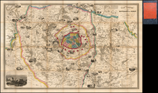
Paris at the Outset of the Haussman Renovations By the Geographer to the French Postal Service.
Fine and elegantly colored example of Xavier Girard's important map of Paris, published in 1857.
The map was issued during the beginning of the Haussmann renovations of Paris, at a time when Girard was serving as the geographer for the French Postal Service. The map is colored according to the Parisian arrondissement system, of which there were only twelve at the time. Roads, public buildings, churches, and more are all shown.
Haussmann's renovation of Paris was a vast public works program commissioned by Emperor Napoléon III, and directed by the Prefect of the Seine, Georges-Eugène Haussmann, between 1853 and 1870. It included the demolition of crowded and unhealthy medieval neighborhoods, the building of wide avenues, parks, and squares, the annexation of the suburbs surrounding Paris, and the construction of new sewers, fountains, and aqueducts. Haussmann's work met with fierce opposition, and he was finally dismissed by Napoleon III in 1870, but work on his projects continued until 1927. The street plan and distinctive appearance of the center of Paris today are largely the result of Haussmann's renovation.
![[Paris World's Fair] Exposition Universelle de 1900 -- Plan General](https://storage.googleapis.com/raremaps/img/small/92123.jpg)
![[ Paris ] La Ville, Cite, Universite, & Faux-Bourgs de Paris](https://storage.googleapis.com/raremaps/img/small/103453.jpg)