


|
||

|

|
|

|
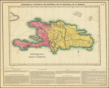
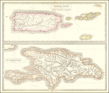
Well-executed plan of the Dominican Republic, published by William Faden during the Haitian Revolution. The map includes a high level of topographic detail and names many rivers and other geographical features. Some detail is provided in the sea, with soundings shown.
The map is colored according to the country that controlled the colony. The blue outline represents French territory, while the yellow outline represents Spanish territory. Notes abound explaining changing toponyms or particular features.
This map was published in the third year of the Haitian Revolution, during the build-up of British troops on the island. The slave rebellion had been supported nearly since the inception by British troops, but the winter of 1794 saw the abolition of slavery in the French Republic, which led to the former slaves switching sides in the conflict, against the British who still supported slavery. However, Britain still wanted to capture the island in order to use it in negotiations against France.
1794 was a difficult year for British troops, with a majority dying of yellow fever. Pitt subsequently launched "the great push," the largest expedition ever organized by Britain. It would be a failure and be defeated by 1797.
William Faden (1749-1836) was the most prominent London mapmaker and publisher of the late-eighteenth and early-nineteenth centuries. His father, William Mackfaden, was a printer who dropped the first part of his last name due to the Jacobite rising of 1745.
Apprenticed to an engraver in the Clothworkers' Company, he was made free of the Company in August of 1771. He entered into a partnership with the family of Thomas Jeffreys, a prolific and well-respected mapmaker who had recently died in 1771. This partnership lasted until 1776.
Also in 1776, Faden joined the Society of Civil Engineers, which later changed its name to the Smeatonian Society of Civil Engineers. The Smeatonians operated as an elite, yet practical, dining club and his membership led Faden to several engineering publications, including canal plans and plans of other new engineering projects.
Faden's star rose during the American Revolution, when he produced popular maps and atlases focused on the American colonies and the battles that raged within them. In 1783, just as the war ended, Faden inherited his father's estate, allowing him to fully control his business and expand it; in the same year he gained the title "Geographer in Ordinary to his Majesty."
Faden also commanded a large stock of British county maps, which made him attractive as a partner to the Ordnance Survey; he published the first Ordnance map in 1801, a map of Kent. The Admiralty also admired his work and acquired some of his plates which were re-issued as official naval charts.
Faden was renowned for his ingenuity as well as his business acumen. In 1796 he was awarded a gold medal by the Society of Arts. With his brother-in-law, the astronomer and painter John Russell, he created the first extant lunar globe.
After retiring in 1823 the lucrative business passed to James Wyld, a former apprentice. He died in Shepperton in 1826, leaving a large estate.
![[ Hispaniola ]](https://storage.googleapis.com/raremaps/img/small/103795.jpg)