


|
||

|

|
|

|
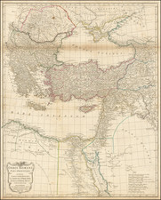
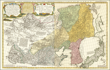
Imagining "Wilsonian Armenia" After The Demise of the First Armenian Republic
Rare map of the wishfully imagined Independent State of Armenia, published in Istanbul in 1923, conjuring an image of the the abortive "Wilsonian Armenia," negotiated, but never formally adopted by the regional power players.
This remarkable Armenian language map of eastern Anatolia and the western Caucuses with text entirely in Armenian advocates that virtually the entire region is the “Natural” territory of what had until recently been a planned and negotiated independent Armenian state. The map is also filled with traditional Armenian names for the major cities, towns, etc.
The dating of the map suggests that it was in fact a propaganda piece published in Istanbul by the prominent Turkish printer Ahmed Ihsan at the tail end of the Armenian Genocide and after the contemporary Armenian independence movement had largely been crushed. The map covers the area of the Caucuses around Yerevan and Lake Sevan (then part of the Soviet Union) and extends west beyond Mount Ararat to include much of eastern Anatolia, taking in Lake Van, and extending up to the Black Sea past Trabzon. The details are drawn from the 1915 Map of Armenia and Adjacent Countries.
The title in Armenian (The Natural Part of Armenia), suggests the area should form part of an independent Armenian state. It is remarkable that Armenians in Istanbul would feel comfortable advocating Armenian claims of this nature in 1923, and equally curious that Ihsan, a member of the establishment in the city would print the map, as its political messaging directly conflicts with new Turkish leader Mustafa Kemal Atatürk’s efforts to integrate traditional ethnic Armenian lands into the Turkey, while the Soviets asserted dominion over the rest of the historical Armenian lands.
The map was published in 1923, shortly after the demise of the First Armenian Republic (June 1918- December 1920), the failed Treaty of Sevres (August 10, 1920) and the conflict period between December 1920 and March 1922, when large parts of Armenia were formally absorbed by the Transcaucasian Socialist Federative Soviet Republic and Turkey, bringing an end the immediate prospects for an Armenian state.
Wilsonian Armenia
Wilsonian Armenia is a term used to described the unimplemented boundary configuration of the First Republic of Armenia in the Treaty of Sèvres, as drawn by U.S. President Woodrow Wilson's Department of State. The Treaty of Sèvres was signed between the Western Allied Powers and the defeated government of the Ottoman Empire in August 1920, but it was never ratified. Wilsonian Armenia included portions of the Ottoman vilayets of Erzurum, Bitlis, Van, and Trabzon, providing the First Republic of Armenia with an outlet to the Black Sea at the port of Trabzon.
By 1923, subsequent events ended the prospect for the so-called Wilsonian Armenia, which would be divided among Transcaucasian Socialist Federative Soviet Republic and Turkey.
Rarity
We note only the example identified by Dasa Pahor in the National Library of Armenia (Yerevan).
![Natolia quae olim Asia Minor [Includes Cyprus]](https://storage.googleapis.com/raremaps/img/small/63981op.jpg)