


|
||

|

|
|

|
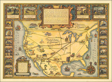
Nice example of the McLoughlin Brother's "New Dissected Map of the United States."
As noted by the Levnthal Map Center description:
Produced by the most successful game maker of the time, this jigsaw puzzle was another method of making geography fun and interesting.
Designed as learning tools, the earliest puzzles, known as "dissected maps," did not contain randomly cut pieces, but rather followed country or state borders. Jigsaw puzzles with random pieces eventually replaced this practice. In this puzzle dating from 1877, a child would become familiar with United States geography.
The puzzle is housed in a decorative box depicting and mother and studying the puzzle pieces.
The map shows a divided Oklahoma Territory, split with the Indian Territory. In all, a delightful piece.
![For Governor, Maj. Gen. John W. Geary [Former Mayor of San Francisco / Governor of Kansas Territory and Governor of Pennsylvania]](https://storage.googleapis.com/raremaps/img/small/93592.jpg)
![(Asian Stereotypes) [Scrapbook of Ching Chow comic strip clippings]](https://storage.googleapis.com/raremaps/img/small/88894.jpg)
![(South Sea Bubble) Vonnis Van Apol Over De Bubbels [Verdict of Apollo Regarding the Bubbles]](https://storage.googleapis.com/raremaps/img/small/94324.jpg)
![[ American Revolution - Satirical Warning To Dutch Commerce ] Den Door List en Geweld Aangevallen Leeuw.](https://storage.googleapis.com/raremaps/img/small/99580.jpg)