|
||

|

|
|

|
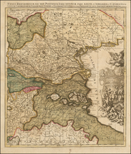
Detailed antique engraved map of northwest Italy during the War of Austrian Succession (1740-48), published by Emanuel Bowen in London in 1747.
The general map features the duchies of Savoy and Piemont, representing the area between Lake Geneva and the Gulf of Genoa. It includes two inset maps: A Draught of the City of Nice and Town of Villa Franca with some part of the Adjacent Coast. and A Plan of Coni a Strong fortified City, situated on a Hill between two Rivers, which renders its approach on the East and West sides very difficult.
Each of the additional map images includes a detailed key below.
Emanuel Bowen (1694?-1767) was a British engraver and print seller. He was most well-known for his atlases and county maps. Although he died in poverty, he was widely acknowledged for his expertise and was appointed as mapmaker to both George II of England and Louis XV of France. His business was carried on by his son, Thomas Bowen. He also trained many apprentices, two of whom became prominent mapmakers, Thomas Kitchin and Thomas Jeffreys.
![(Turin) Nuova pianta della citta di Torino [New Map of the City of Turin]](https://storage.googleapis.com/raremaps/img/small/86314.jpg)
![[Gateway to the Cinque Terre] The Gulf of Spezia](https://storage.googleapis.com/raremaps/img/small/72873.jpg)