


|
||

|

|
|

|
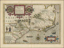
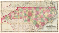
The Hondius Composite Map of Virginia, Responsible for Perpetuating Misconceptions for a Century and a Half
Fine example of Jodocus Hondius's important map of Virginia and the Carolinas, from the Mercator-Hondius Atlas Sive Cosmographie . . .
Hondius utilized John White's map of Virginia and Jacques Le Moyne's map of Florida to create what is basically a composite of these two important late 16th-century Virginia maps. The map had a profound impact on the mapping of the region for much of the 17th century and became the prototype map for the region until the Ogilby-Moxon "Description of Carolina" ca. 1672.
Details based on Le Moyne include the gold-bearing mountains of "Apalatcy," the lake fed by the great waterfall, the lake with the unseen shore, Lake Sarrope, the French names for the rivers, and the location for the French fort at Port Royal.
In addition to creating a composite, Hondius does contribute some new information. The large lake with the opposite shore invisible, which in Le Moyne lies in a southwesterly direction from the mouth of the River May, having been moved northward to the foothills of the Apalatcy Montes. This makes the River May flow in a southeasterly direction instead of in the A-shaped course given by Le Moyne. This reflects the additional sources used in the making of the map, including Mercator's World map of 1569, the second edition of Ortelius' map of America (1584), and Wytfliet's map of the Southeast, first issued in 1597, in which the river Sola flows in a southeasterly direction from the mountains.
According to Cummings, the River May is Le Moyne's name for St. Johns River in Florida, on which Fort Caroline was built. By putting the lake and the direction of the River May to the northwest of its mouth, and changing the accompanying topographical features and Indian settlements, Hondius created geographical misconceptions of the region, which lasted for nearly 150 years. He also moved the latitude of the mouth of the River May from 29°30' N.L. (St. Johns is 30°25') to 31°20'. This is actually the latitude of the Altamaha in Georgia, the first river above Florida which has its source in the Appalachian range. These factors undoubtedly encouraged the continuance of erroneous beliefs in the minds of subsequent explorers and cartographers. St. Marys River, which lies between St. Johns and the Altamaha, rises in the Okefenokee Swamp. Some writers think that the River May is the St. Marys River and that the great lake is the Okefenokee Swamp.
A turkey and wild other game are engraved, along with sea monsters, an indigenous canoe, sailing ships, and other attractive decorative elements. The map includes two cartouches and two insets of Floridian and Virginian cities.
Editions
The presented issue dates from the 1634 Dutch edition.
Jodocus Hondius the Elder (1563-1612), or Joost de Hondt, was one of the most prominent geographers and engravers of his time. His work did much to establish Amsterdam as the center of cartographic publishing in the seventeenth century. Born in Wakken but raised in Ghent, the young Jodocus worked as an engraver, instrument maker, and globe maker.
Hondius moved to London in 1584, fleeing religious persecution in Flanders. There, he worked for Richard Hakluyt and Edward Wright, among others. Hondius also engraved the globe gores for Emery Molyneux’s pair of globes in 1592; Wright plotted the coastlines. His engraving and nautical painting skills introduced him to an elite group of geographic knowledge seekers and producers, including the navigators Drake, Thomas Cavendish, and Walter Raleigh, as well as engravers like Theodor De Bry and Augustine Ryther. This network gave Hondius access to manuscript charts and descriptions which he then translated into engraved maps.
In 1593 Hondius returned to Amsterdam, where he lived for the rest of his life. Hondius worked in partnership with Cornelis Claesz, a publisher, and maintained his ties to contacts in Europe and England. For example, from 1605 to 1610, Hondius engraved the plates for John Speed’s Theatre of the Empire of Great Britaine.
One of Hondius’ most successful commercial ventures was the reprinting of Mercator’s atlas. When he acquired the Mercator plates, he added 36 maps, many engraved by him, and released the atlas under Mercator’s name, helping to solidify Mercator’s reputation posthumously. Hondius died in 1612, at only 48 years of age, after which time his son of the same name and another son, Henricus, took over the business, including the reissuing of the Mercator atlas. After 1633, Hondius the Elder’s son-in-law, Johannes Janssonius, was also listed as a co-publisher for the atlas.
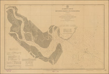

![[Untitled Coast chart of North Carolina, South Carolina, Georgia, and Florida, with insets of the harbor of Charleston, S.C. and the entrance of the Saint Johns River]](https://storage.googleapis.com/raremaps/img/small/91737.jpg)