|
||

|

|
|

|
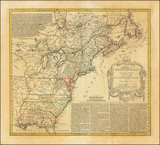
Nice example of Ottens's uncommon map of the British and French possessions in North America, which reflects French and English claims in the region on the eve of the French and Indian War.
The map is drawn directly from John Palairet's highly important map of the same title, which accompanied Palairet's A Concise Description of the English and French Possessions in North-America. . ., published in London in 1755.
The map depicts the English Colonies in yellow and the French Colonies in green. Areas that were disputed, the basis for the French and Indian War, are in pink. Consistent with the notes in the legend, the French forts are identified in red and most are also circled. Owing to his Dutch connections, Palairet's map was undoubtedly available very quickly in Amsterdam and this Dutch edition provides a fine snapshot of the English vision of the French encroachments into regions which the English were seeking through alliances with the Indians and early settlements. It would be only a matter of months before the disputed area shown on the map would lead to open conflict.
Jean Palairet was an English mapmaker born in France. At the time of publication, he was serving as the agent to the Dutch States-General in London. Palairet's map is one of the earliest folio-sized maps of the Colonies to incorporate the information from John Mitchell's seminal 8 sheet map.
The map shows the cartographic features present in the first state of Palairet's map, predating the revision which would show the northernmost boundary line as a straight line separating the British Hudson Bay claims from the French Canadian claim. A second east-west boundary line also runs through Canada.
Palairet's rare map and his accompanying pamphlet were published simultaneously in English and French and provide a fascinating picture of the North American Colonies on the eve of the French & Indian War. It describes the relevant facts in dispute between the two claimants in 69 pages. In the preface of his pamphlet, Palairet notes:
The method in which I have coloured it, will easily discover the English and French Possessions, as well the countries that are now the subject of contest between those two nations, as the forts which the French have built, or taken in the midst of the English Colonies, and in the countries claimed by the English."
The pamphlet describes the events leading up to the conflict in much detail. Together the map and pamphlet are very rare, so much so that Thomas Streeter believed his copy to be unique.
The Ottens brothers, Reiner and Joshua, operated a successful printing partnership in the mid-eighteenth century (fl. 1726-1765). They began the venture in 1726, publishing maps and other prints as “R & I Ottens.” They specialized in the reprinting of others’ work, especially Guillaume De L’Isle. In 1750, Reiner died; his soon, also Reiner, took his place, but the firm began listing their works as “Joshua & Reiner Ottens.” The firm lasted until Joshua’s death in 1765. Joshua’s widow, Johanna de Lindt, sold their remaining stock of plates in 1784.
![[Early Montana Territory Shown Above Idaho] Johnson's New Military Map of the United States Forts, Military Posts & all the Military Divisions with Enlarged Plans of the Southern Harbors . . . (Shows Military Departments)](https://storage.googleapis.com/raremaps/img/small/93868.jpg)
![[ Chinese Voyages To America, etc. ] Memoires De Litterature, Tires Des Registres De L'Academie Royale Des Inscriptions et Belles-Lettres Depuis l' annee M. DCC. XVIII. julques & compris l'annee M. DCC. XXV Tome Quarante-Neuvieme](https://storage.googleapis.com/raremaps/img/small/101296.jpg)