|
||

|

|
|

|
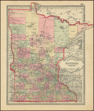
Scarce large format map of the Upper Mississippi Valley and adjacent regions, one of the most detailed and important maps of the region during the period.
The map, which covers part or all of present-day Minnesota, Wisconsin, Iowa, and Illinois, was produced by the U.S. Topographical Bureau in 1836, when this area was almost completely unsettled by White Americans.
The following treaty lands and early grant and district lands are illustrated on the map:
- Carver's Grant
- Sioux Cession to the U.S.
- Sac and Fox Session to the U.S.
- Ceded to U. S. For Indian Purposes
- Chippewas and Pottawattamies 5,000 Acres
- Sacs and Foxes 1700 Total
- New Purchase
- Scot's Purchase
- Half Breed Tract
- Quincy Land District
- Alena District
- Preservation of 400 Square Miles
- Wisconsin District
- Winnebagoes
- Milwaukee District
- Green Bay District
- Menomonies
- Agricultural Tract of the Menomonies
- N.Y. Indians.
While almost all of these configurations were quite ephemeral, they played an important role in 19th-century settlement patterns that can still be felt today.
Around the Twin Cities, Fort Snelling, Lake Calhoun, Falls of St. Anthony, Carver's Cave, an American Fur Company settlement, and Little Crows Village can all be seen. Chicago is named.
Between 1835 and 1837, George Featherstonhaugh, a British scientist, began his journey in Washington, D.C. and traveled via Pittsburgh and Cleveland before visiting Detroit, and traveling by canoe on Lakes Huron and Michigan to Mackinac and Green Bay, thence via the Fox and Mississippi Rivers to Saint Anthony and Fort Snelling, where Featherstonhaugh's party ascended the Minnesota River as far as Lake Traverse on the Dakota border, and back again via Lake Pepin, Galena, and Saint Louis. His travels by canoe in Wisconsin and Minnesota are of particular interest.
The map is in essence the last general map of the region prior to Nicollet's map and provides an excellent visual counterpoint to Nicollet, illustrating, by contrast, the vast advances made by Nicollet in the region. Featherstonhaugh's map is an essential stepping stone in illustrating the evolution of the cartographic history and evolution of the Upper Mississippi Region and an essential map for regional collectors.