|
||

|

|
|

|
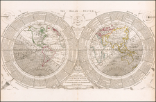
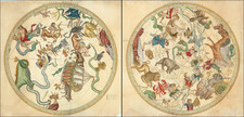
A bird’s-eye view of the floor design of the Amsterdam Town Hall in the second half of the 17th century, showing the one of earliest public depictions of Tasman’s discoveries on the Australian continent.
The marble mosaic map was laid in 1648 but was later removed as traffic across the floor gradually damaged the design. It depicts the two hemispheres and a celestial chart of the Northern Hemisphere.
At center is a celestial map of the northern sky with the Western and Eastern Hemispheres on either side. California is shown as an island as would be expected for a map of this period. However in the Eastern Hemisphere is one of the earliest depictions of Abel Tasman's discovery of Tasmania. Tasman made those discoveries in 1642-43. However, it was several years before the results of the exploratory voyages were made public due to the secretive nature of the East India Company and their desire to maintain its monopoly on trade in the region.
The map appeared in Jacob van Campen's work detailing the Civic Hall of Amsterdam on thirty copper plates.
The floor inspired the magnificent Tasman Map floor mosaic in the vestibule of the Mitchell building in Canberra, Australia.