|
||

|

|
|

|
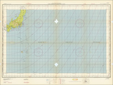
Large scale, detailed strategic map of Iwo Jima, prepared in the Fall of 1944 leadup to the U.S. assault on the island.
The map was prepared for CINCPAC-CINCPOA by the 64th Engineer Topographic Batallion in October of 1944. The map was based on aerial photography but warns that it was not corrected ground control or reconnaissance and therefore was in need of updating.
One of the unusual and valuable aspects of this map is that it records long notes on the beach quality thought to be encountered at the coded landing zones. For instance, at Blue-2 the note reads:
Beach varies from 150' to 280' in width, being widest at the center where 2 wrecked LSMs are beached. An abrupt, almost vertical 5' rise backs the S end of the beach. 40 yards inland of this rise is a second more gentle rise. The two rises converge at the center of the beach, the total height there being 12'-15', almost vertical. The northern half of the beach is backed by a steep 15'-20' bluff. 50-60 yards seaward of this bluff, on the beach, is a sharp rise of 3'. The terrain inland of the steep bluff has a moderate slope. The only suitable vehicular means of exit appears to be the road leading up over the bluff inland.
The early reports of the beach quality on Iwo Jima became infamous when the attacking Marines realized that the soft volcanic ash-sand impeded the movement of troops and vehicles enormously.
The legend denotes the following strategic emplacements:
Blockhouse
Coastal Defense Gun
Dual Purpose Gun
Heavy AA
Medium AA
Machine Gun or Lt. AA
Anti-Tank, Anti-Boat Gun
Covered Arty. Emplacement
Open Arty. Emplacement
Rifle Pit
Unidentified Installation
Cave or Underground Entrance
Buried Stores
Loose Stores
Pillbox
Searchlight
Command Post
Range Finder
Radar
Observation Tower
Fuel Storage
Personnel Trench
Trench & Rifle Pits
Anti-Tank Trench
Excavation - Approx. 10'x20'
Tank Barrier
Barbed Wire
Ammo Dump
Iwo Jima, whose name translates as "Sulfur Island", was an important midway point between South Pacific bomber bases that were already in the hands of the Allies and the Japanese home islands. 700 miles from Tokyo and 350 from the nearest U.S. airbase, with a central plain suitable for building large runways, American planners viewed it as a valuable target. The battle for the island was among the bloodiest of the Pacific Theater of the Second World War. In total, 6,800 U.S. Marines lost their lives and 26,000 were wounded, while a staggering 18,000 Japanese defenders died.
![(Second World War - Bombing of Japan) Tachiarai AF RESTRICTED [Three Reconnaissance Photos of Tachiarai Air Force Base]](https://storage.googleapis.com/raremaps/img/small/90451.jpg)