


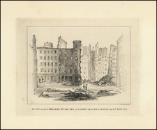
|
||

|

|
|

|
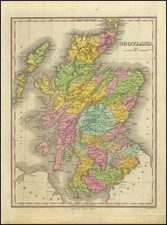
Attractive vintage map of Scotland, showing the historical distribution of clans in the Highlands. The central map is color-coded and names dozens of clans, including the Mackenzies, Macdonalds, Macgregors, and Grants, and shows their historical lands. The Lowlands (southern Scotland) are labeled but not color-coded, and show the lands belonging to clans including the Balfours and the Hamiltons.
In addition to naming the clans, the map also names and shows numerous lochs, cities, forts, islands, and other Highland geographic features. The map is surrounded by sixty different tartan patterns, as well as eighteen depictions of clan members.
The clan system, as understood by popular sentiment, is a figment of Romantic conjecture. While clans were certainly the central power structure in most of Scotland until the Restoration, the image of noble families and clans ruling all of Scotland, with associated kilts, is largely due to Sir Walter Scott's work in popularising this image. Rather, most clanmembers were not related by blood ties. Clans were simply an extension of feudal Europe, where ruling landowners controlled small regions of "crofted" land, with tenant farmers often bound to the land.
![[ Scotland ] A New Map of Scotland or North Britain Drawn from the most approved Surveys and Regulated by Astronomical Observations, By Lieutenant Campbell . . . 1794](https://storage.googleapis.com/raremaps/img/small/102873.jpg)
![(British Isles) Tabu Moder Anglie & Hiber [Modern Map of England and Ireland]](https://storage.googleapis.com/raremaps/img/small/103164.jpg)