|
||

|

|
|

|
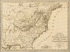
Rare map of the US, illustrating a number of the early territories. Indiana Territory includes all of Michigan, Illinois, and the regions east of the Mississippi extending to Canada, & encompassing the Mascountin, Wenebago, Monomoni, Chippeway, Mosquite, Illinois, Wootenos and Tchiktashik Tribal lands. While Ohio appears to extend to the Wabash, it is proabably mislabeled and should be the misprojected strip below Lake Erie. Georgia extends to the Mississippi, w/many Indian Tribes within. Along the Mississippi are several historical notes, including reference to De Soto. The territorial names of Orleans, Mississippi and Louisiana appear west of the Mississippi, as do several forts and posts. Trimmed nearly to neat line, else a marvelous rarity.
![[ Atlas - Florida and Southern Canal Projects ] Travaux d'améliorations intérieurs projetés ou exécutés par le gouvernement général des États-Unis d'Amérique, de 1824 à 1831 [complete with:] Travaux d'améliorations intérieurs projetés ou exécutés... Atlas.](https://storage.googleapis.com/raremaps/img/small/85067.jpg)