|
||

|

|
|

|
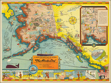
Interesting quasi-pictorial map promoting travel from the United States to the "Canadian Twin Cities" of Port Arthur and Fort William on Thunder Bay, Lake Superior.
The map covers the Minnesota Arrowhead region into Canada, as well as western Lake Superior with illustrations of an American Indian, moose, deer, canoeing, etc., laid over the map. In the lower-right are photographs of the Royal Edward Hotel and other local landmarks.
The makers of the map, the Tourist Bureau of Fort William and Chamber of Commerce Port Arthur, seem particularly keen on attracting visitors from Duluth, Minnesota.
On the verso is an extensive essay expounding on the reasons to travel up the North Shore to Canada. There are also photographic vignettes of things to be seen along the way, such as Kakabeka Falls, Splitrock Lighthouse, Cross River, and Arrowhead River. There is also a map of the region in context titled: "Highways To The Land of the Nipigon - Canada".
![[Upper Missouri River, Lake Winnipeg, Lake of the Woods and Skatehawan River] Amer. Sep. No. 33. Partie De La Nouvelle Bretagne](https://storage.googleapis.com/raremaps/img/small/80101.jpg)