


|
||

|

|
|

|
A Revolutionary-Era Rarity Featured on the Cover of Krieger and Cobb's Mapping Boston.
An exceptional example of this rare Revolutionary War-era French plan of Boston.
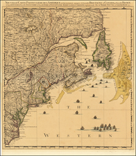
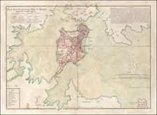
This map is a beautiful rendition of Boston. The map shows Charlestown to the north and Dorchester and Roxbury to the south. The map locates Faneuil Hall and many other colonial Boston landmarks. It illustrates the Boston Common and Beacon Hill, and many of the roads are named. The text in the upper right describes life in Boston, focusing on its defenses and its monuments, but also describing its market and fair days.
Boston Public Library says of the map:
This is the earliest detailed plan of the city of Boston published in France. Beautifully engraved and colored in the best style of French manuscript and printed maps, it shows streets, houses, public buildings, wharves, Beacon Hill, the Common, and other points of interest. Bellin, hydrographer to the King of France, published many fine maps of America under the auspices of the French Marine Office. This plan of Boston Harbor was probably copied from an English survey for use during the French and Indian War.
The talent and skill of Jean Lattré, a French publisher and engraver, are displayed in this attractive map of the immediate environs of Boston. The city and harbor command a sparse but forceful appearance in which the clarity of the engraving is complemented by the richness of the full wash color. The city itself is carefully rendered, with each existing street shown, including King Street extending inward from the Long Wharf toward the State House and site of the Boston Massacre. It is particularly useful in illustrating the circumstances of the Massacre and the days that followed, for it includes within the Harbor an inset of the fortified island upon which Castle William stood - the location to which the British regiments retreated according to Hutchinson's report.
Dating the Map
Michael Buehler of Boston Rare Maps has recently dated this map to the early Revolutionary period, a conclusion supported by his research into the Lattré papers and a re-examination of the map's contents. Traditional scholarship had assumed a circa 1764 date for the map, in line with most of Bellin's work, but this date is impossible due to the presence of the "Arbre de Liberté" [Liberty Tree] in Boston Common. This name did not come into common usage until at least 1765 in Boston, and its appearance on a French map would make little sense until the early 1770s.
The argument is strengthened by research into the Lattré papers held by the Clements Library. The map is unlisted in Lattré's catalogs from 1764 and 1773, but does appear in his catalogs of 1777 and 1784. Further, Lattré changed his address to "vis-a-vis la rue de la Parcheminerie" from "a la ville de Bordeaux" in the mid-1770s, all but ensuring a date of the map to between 1773 and 1777. Further, a second state of the map includes updates from the 1776 Richard Williams Plan of Boston and its Environs shewing the true Situation of His Majesty's Troops. . ., which would date the first state of this map to between 1773 and 1775.
Bellin Authorship
This map is generally ascribed to Jacques Nicolas Bellin, as suggested by the BPL description above. However, there is no indication that Bellin was involved in this project, and the map does not resemble Bellin's other works on the region. It has been suggested that Lattré used a compendium of sources, including the 1769 William Price edition of John Bonner's map of Boston. However, that map does not include the Liberty Tree or Commons, suggesting that Lattré may have had access to additional, now unknown, manuscript sources.
States and Editions
This is the first state of the map. The second state includes several updates, such as a road that continues from Boston Neck to Roxbury and the addition of a box around the text in the upper right.
Rarity
We can find only one example of this map having been on the auction market in recent decades, at Skinner Auctions in 2005 where it made $22,350.
Jean Lattré (fl. 1743-1793) was a Parisian bookseller and engraver who published many maps, plans, globes, and atlases. He worked closely with other important French cartographers, including Janvier, Bonne, and Delamarche, as well as other European mapmakers, such as William Faden, Santini, and Zannoni. Lattré is also interesting due to his propensity to bring suits against those who copied his work; plagiarism was common practice in eighteenth-century cartography and mapmakers struggled to maintain proprietary maps and information.
![[Battle of Lexington] Journee de Lexington . . .](https://storage.googleapis.com/raremaps/img/small/94722.jpg)