|
||

|

|
|

|
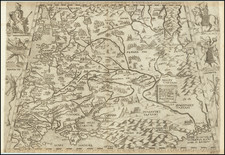
Guillaume Levasseur de Beauplan Maps The Ukraine
Detailed map of the north central part of Ukraine, drawn from the maps of Guillaume Levasseur de Beauplan, published by Nicolas Sanson.
The map tracks the course of the Dnieper River across the center of the map, extending North Poliske, Chernihiv and the northern Ukraine borders with Belarus and Russia, and south to the area around Dnipro, Kropvnytskyi and Torhovystya.
Kiev and Poltava are shown.
Guillaume Levasseur de Beauplan
Guillaume Levasseur de Beauplan (1600 – 1673). Beauplan was a French geographer and military engineer who went to Poland at the invitation of King Sigismund III and, assigned to the Ukraine, stayed 17 years building fortresses and castles and surveying its lands.
Beauplan served as artillery captain for the army of the Crown of the Kingdom of Poland between 1630 and about 1648. During that time, he was sent to Ukraine where he served under Stanisław Koniecpolski in 1637–38. He was active mainly on the eastern frontiers, where he supervised the building of fifty fortresses and set out hundreds of villages. In 1639, he participated in a surveying expedition down the river Dnieper. About this time he drew a sketch map of southern Ukraine, the “Tabula geographica Ukrainska,” which has been preserved in the “Topographica practica,” a collection of manuscript maps and charts assembled by Frederick Getkant by order of Ladislaus IV.
Beauplan made a general map of Ukraine, Delineatio generalis camporum desertorum vulgo Ukraina cum adiacentibus provinciis, which was published in Gdansk in 1648. In 1651, he published a description of Ukraine, which was limited to the Crimea and the lower course of the Dnieper and was printed in only one hundred copies After years of work, Beauplan had expected a generous reward for his services, but King Ladislaus IV died in March 1648, dashing any hope of compensation. In 1654 John II (John Casimir) of Poland granted Gdansk printer Georg Förster and historian Joachim Pastorius the privilege to print the maps and the description of the kingdom’s provinces—in other words, to finish the work Hondius and Beauplan had started.
Beauplan wrote Description des contrés du Royaume de Pologne, which was published in 1651. The work was retitled Description d'Ukranie, when the second edition was released in 1651. Two more editions were published in 1660 and 1861. The book was the first book published that provided a geographical, economic, and demographic description of Ukraine.
Nicholas Sanson (1600-1667) is considered the father of French cartography in its golden age from the mid-seventeenth century to the mid-eighteenth. Over the course of his career he produced over 300 maps; they are known for their clean style and extensive research. Sanson was largely responsible for beginning the shift of cartographic production and excellence from Amsterdam to Paris in the later-seventeenth century.
Sanson was born in Abbeville in Picardy. He made his first map at age twenty, a wall map of ancient Gaul. Upon moving to Paris, he gained the attention of Cardinal Richelieu, who made an introduction of Sanson to King Louis XIII. This led to Sanson's tutoring of the king and the granting of the title ingenieur-geographe du roi.
His success can be chalked up to his geographic and research skills, but also to his partnership with Pierre Mariette. Early in his career, Sanson worked primarily with the publisher Melchior Tavernier. Mariette purchased Tavernier’s business in 1644. Sanson worked with Mariette until 1657, when the latter died. Mariette’s son, also Pierre, helped to publish the Cartes générales de toutes les parties du monde (1658), Sanson' atlas and the first French world atlas.
![[Map of the Kiev Region] КАРТА КІЕВСКАГО НАМѢСТНИЧЕСТВА](https://storage.googleapis.com/raremaps/img/small/57871.jpg)
![[ Ukraine ] Typus Generalis Ukrainae sive Palatinatuum Podoliae, Kioviensis et Braczlaviensis terras nova delineatione exhibens](https://storage.googleapis.com/raremaps/img/small/104149.jpg)