


|
||

|

|
|

|
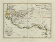
The British Factory of Sherbro -- Slave Trade
Interesting early 18th Century map of a part of the West Coast of Africa, with an inset of the British Factory at Sherbro, a center of the British slave trade in the 18th Century.
By 1628, the British set up a "factory" at Sherbro. Beginning about 1660, the area was controlled by the Royal African Company, which had its base at York Island (named for the Duke of York), until 1719.
The absence of a central trading company gave an opening for a number of fortune-seeking opportunists to set up as slave-traders on the Sierra Leone coast. Sherbro Island remained a center of the slave trade until General Charles Turner brought the island and adjacent areas under British protection in 1825.
Herman Moll (c. 1654-1732) was one of the most important London mapmakers in the first half of the eighteenth century. Moll was probably born in Bremen, Germany, around 1654. He moved to London to escape the Scanian Wars. His earliest work was as an engraver for Moses Pitt on the production of the English Atlas, a failed work which landed Pitt in debtor's prison. Moll also engraved for Sir Jonas Moore, Grenville Collins, John Adair, and the Seller & Price firm. He published his first original maps in the early 1680s and had set up his own shop by the 1690s.
Moll's work quickly helped him become a member of a group which congregated at Jonathan's Coffee House at Number 20 Exchange Alley, Cornhill, where speculators met to trade stock. Moll's circle included the scientist Robert Hooke, the archaeologist William Stuckley, the authors Jonathan Swift and Daniel Defoe, and the intellectually-gifted pirates William Dampier, Woodes Rogers and William Hacke. From these contacts, Moll gained a great deal of privileged information that was included in his maps.
Over the course of his career, he published dozens of geographies, atlases, and histories, not to mention numerous sheet maps. His most famous works are Atlas Geographus, a monthly magazine that ran from 1708 to 1717, and The World Described (1715-54). He also frequently made maps for books, including those of Dampier’s publications and Swift’s Gulliver’s Travels. Moll died in 1732. It is likely that his plates passed to another contemporary, Thomas Bowles, after this death.

![[ Sierra Leone to Côte d'Ivoire ] Pas-caert vande Gryen-Cust en Adaows Qua Quaas Tuhessen de Serraliones en C. de Tres Puntas . . . .](https://storage.googleapis.com/raremaps/img/small/99332.jpg)
![[ Africa. ] Tabula IIII. Aphricae. Hae Sunt E Cognitis Totius Orbis . . . (title on verso)](https://storage.googleapis.com/raremaps/img/small/103154.jpg)