


|
||

|

|
|

|
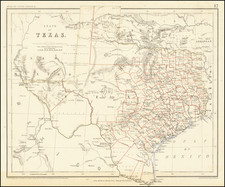
1836 Texas Revolution edition of the Austin map of Texas, arguably the single most important map in Texas history, and one of the great rarities of cartographic Americana.
An extremely important Texas Revolution-association copy of Stephen F. Austin's Map of Texas, the most important map in Texas history.
The Stephen F. Austin Map of Texas occupies an important place in American and Texan history and the progress of westward expansion. As the first broadly accurate map of Texas to be published, it represents a monumental scientific achievement and defined the geographic conception of Texas before and during the Republic period. It also proved to be a brilliant rhetorical device promoting Anglo-American settlement and the cause of Texan independence.
This edition is particularly special, as it is the first issue of 1836, a momentous year in Texas history. This first issue of 1836 was published before the Battle of the Alamo and so can be differentiated from the issue that followed later in the year by the fact that it makes no mention of that battle in San Antonio de Béxar. This small bit of evidence indicates that this edition, and likely this example of the map, was taken into the field in by Texan forces during the Texas Revolution.
Texas Revolution Connection
During the Texas Revolution (October 2, 1835 – April 21, 1836), Stephen F. Austin's map was issued at least twice; once in 1835 (probably printed in early November of that year), and then twice in 1836, once before the Alamo and once in May after news had reached Philadelphia.
On May 14, 1836, The United States Gazette of Philadelphia published the following notice about the printing of an updated edition of the map:
Mr. H.S. Tanner has published a map of Texas, corrected recently by Gen. Austin. Some of the copies are mounted on rollers - others are bound bookwise, for pocket use. The map is large, and executed in Mr. Tanner's best manner. It will be doubly acceptable now that troubles have occurred in the state, and that a claim is likely to be set up by the president of the United States, to a slice from the eastern division.
The relationship between this specific example of the map and the Texas Revolution is strengthened by the early ink tracings of routes around Texas. These routes roughly correspond to the campaign routes during the war and might represent a contemporary attempt to trace the movements of Santa Anna and/or Texan forces. In the south, the route begins at Matamoros, where Urrea and Santa Anna began their movement into Texas, it continues to San Antonio de Béxar, where the Battle of the Alamo took place, there it splits in several directions, but the main important route is to San Felipe de Austin, before looping south and east toward Galveston Bay, before culminating in a number of emphatically sketched "X"s approximating the location of the Battle of San Jacinto.
Description
As will be discussed below, Austin compiled this map over the course of more than five years, both to fulfill a condition of his land grant from Mexico and to showcase Texas’s attractions to potential settlers. The landscape is thus shown to be as inviting as possible. The natural topography—in particular the profusion of river and stream systems—is depicted “with accuracy that far outstrips that of any previous map” (Cohen, p. 113) The three earliest colonial grants—Austin’s Colony, De Witt’s Colony and the second Austin Grant—are shown in well-watered country in the southeast. The progress of development in Austin’s Colony is emphasized by a number of American towns, many appearing for the first time on a printed map. These are shown linked to one another, to the United States and to the Mexican interior by an extensive road network. Beyond the grants are vast areas of prairie populated by “large” and “immense” “droves” of wild cattle, horses and buffalo, but also the domain of the fearsome Comanche nation.
“This rare map of Texas was part of Austin’s campaign to encourage settlers to take up homesteads on his lands. The huge Austin grants are clearly marked and are made as attractive cartographically as possible. The map is the result of years of work by Austin himself in gathering and refining the necessary data.” (Clements Library, Fifty Texas Rarities, #10)
In an astute tribute to Austin’s benefactors, the title block is surmounted by the Mexican coat of arms, a golden eagle holding a snake in its beak and talons, surmounting a prickly pear cactus bearing the name of each Federal state.
How Austin’s map became the cartographic “birth certificate” of Texas
The creation of Austin’s map lies at the very center of the founding of modern Texas. Prior to the 1820s “Tejas” had been a largely neglected frontier province of New Spain, which was in the throes of the revolution that would shortly establish Mexico’s independence. The non-indigenous population numbered only 2,500, centered on a handful of missions and presidios, and development was hindered by the resistance of Comanche and Apache warriors who resented European encroachment. In the final days of its control of Mexico, the Spanish regime granted concessions to foreigners to settle certain frontier regions, in order to act as bulwarks against the native peoples and developing the fertile land into a taxable province. One such concession was given in January 1821 to American Moses Austin, with the proviso that he settle 300 Catholic families along Texas’s Brazos River. Austin died shortly thereafter, and title passed to his son, Stephen.
In 1822, Austin’s grant was rescinded during the political turmoil following Mexican independence. He traveled to Mexico City in an effort to lobby the government and, clearly understanding the power of cartography, drafted the Mapa geographico de la provincia de Texas (1822) to support his efforts. While a crude endeavor when compared to his later work, this was for its time the most geographically advanced map of the region.
In 1823, Austin succeeded in convincing the Mexican Congress to reinstate his grant and was given the title of “empresario,” or agent of the colonizing scheme. He then set about attracting settlers to his colony, with the first wave of families–“the Old Three Hundred”–arriving late in 1825. As depicted on his map, over the rest of the decade, the territory of Austin’s grant was progressively expanded, as he managed to attract a further 900 people to his colony. During the same period, other American impresarios founded colonies, as shown on the map, beginning with “De Witt’s Colony,” shown on the map just west of Austin’s. While conditions were challenging, most of these colonies succeeded in establishing permanent settlement. While technically all new immigrants were to swear allegiance to Mexico as citizens, practice Roman Catholicism, learn Spanish, and observe a prohibition on slavery, these stipulations were rarely enforced. Gradually, a new society developed, demographically and culturally distinct from the rest of Mexico.
Austin’s 1823 grant also required him to produce an accurate general map of Texas, an effort he pursued diligently. He had a voracious appetite for geographic information, and solicited land surveyors for any and all plat maps and regional surveys. His efforts were rewarded by some fine surveys, notably John Kerr’s sketch of the mouth of the Lavaca River and John Williams’ charting of the region between the Sabine and Trinity rivers. Additionally, Austin took the time to perform his own surveys. In 1826, he charted Galveston Island and Bay, and in a separate effort, mapped the courses of the Colorado and Brazos Rivers. This resulted in his manuscript Map of Texas by S F Austin, Bexar, August 8, 1827, a distinct improvement over his 1822 map.
Austin also received assistance from an unlikely source. When in 1828 Mexican president Guadalupe Victoria began to suspect that Anglo-American immigration was a thinly-veiled endeavor to annex Texas to the United States, he dispatched General Manuel de Mier y Téran to the region. During his mission, Téran conducted scientific surveys regulated by astronomical observations. He added some of his findings to a copy of Fiorenzo Galli’s Texas (1826), which, lithographed in Mexico City, was the first printed map of Texas, today known in only a single copy. Although Téran and Austin were supposedly at political cross-purposes, the two men became friends and shared geographic intelligence, a contribution acknowledged by Austin in the title block of his 1830 map.
Publication of Austin’s map
In June 1829 Austin sent his finished manuscript map to Henry Schenk Tanner (1786-1858), who was then the most respected and successful American map publisher, responsible for such grand projects as A New American Atlas (1819-23). Tanner engaged Philadelphia engravers John and William Warr, and the first edition was published in March 1830, printed on thin paper and folded into leather-covered boards. A Taliaferro points out, “This format, handy for travelers, succeeded in keeping with Austin’s intentions, for he hoped that the map would encourage further immigration to Texas.” (Cohen, p. 113)
Fulfilling the condition of his grant, Austin sent another manuscript version of the map, but with Spanish text, to Mexico City, hoping that it would eventually reach the desk of President Vincente Guerrero. In doing so, he sought to assure Chapultepec Palace of his loyalty, writing that:
“I perform this service to my adopted country in deference to the duty of a citizen and in case his excellency the president should esteem it proper to command the map to be engraved and published I grant to the national government for that purpose all the rights to the map which belong to me by the law as its author.”
On another occasion, Austin assured the Mexican Treasury Secretary that: “My purpose [in making the map] has been to add to the fund of geographic knowledge of Mexican territory, and to make known our beloved Texas to the Mexicans and the world.” It is not clear what high-level administrators in Mexico City made of the map, and at any rate, they never arranged for its publication.
Indeed, Austin’s map was in effect the centerpiece of a clever double-sided propaganda campaign. By having the map published and disseminated in the United States, he hoped to promote Texas and to attract additional American immigrants. On the other hand, by sending a special copy of the map as a tribute to the Mexican government, he hoped to assure them of his loyalty, and by extension, that of the Anglo-Texan colonists in general. He knew that the future of Texas he wished to create would be in jeopardy if he did not maintain the tolerance, if not the support, of the Mexican government.
While Austin was successful in promoting Texas within the United States, he failed to gain the favor of the Mexican government. The Anglo-American settler population reached 30,000, outnumbering the Mexican-born citizens by a factor of four to one. The Mexican government feared that this demographic shift was a threat to its national security. As the first copies of Austin’s map appeared from Tanner’s press, President Anastasio Bustamante enacted the new laws of April 6, 1830, which effectively banned all foreign immigration to Texas. The American settlers in Texas and the Mexican government were now on a collision course, one which would culminate in war, independence, and ultimately annexation of Texas to the United States. Austin himself lived just long enough to see the Republic of Texas declare its independence in 1836.
Austin’s legacy would survive him in the form of his great map. Tanner published successively updated issues in 1833, 1834, 1835, 1836, 1837, 1839, 1840, 1846, and 1848. In the early years of the Republic, the Austin map would be imbued with a new symbolic significance. While the Lone Star Republic maintained de facto independence, it was never recognized by Mexico and remained under constant threat of invasion. While the map does not specifically proclaim succession from Mexico, it nevertheless shows Texas to be a clearly defined and separate political entity, traversed by the improvement of the Anglo-Texan colonists.
Thomas Streeter himself described Austin’s map as “the map of Texas I most prize.” (Bibliography of Texas, III:I, p. xv)
In all, a superb example of the most important map in Texas history, this edition from the year of Texas independence, and probably carried in the field during the Texas Revolution.
Rarity
All editions of Austin's maps are rare on the market. Both states of the 1836 Austin are together known in only four institutional collections (Library of Congress [unknown state]; Texas State Library and Archives [first state]; British Museum [unknown]; and Yale, ex. T.W. Streeter [unknown]). The most recent appearance of an 1836 Austin (the second state, including the Alamo) on the market was with Dorothy Sloan in 2013, when the map sold for $245,000.
![[Texas Centennial Exposition]](https://storage.googleapis.com/raremaps/img/small/76381.jpg)
![Carte De La Louisiane Et Du Cours Du Mississipi . . . Juin 1718 [1st State!]](https://storage.googleapis.com/raremaps/img/small/59797.jpg)