
This item has been sold, but you can enter your email address to be notified if another example becomes available.


|
||

|

|
|

|
Stock# 7615
Description
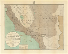
Early regional map of Southern California, showing San Diego, Pt. Loma, False Bay, Bahia de los Temblores (Earthquake Bay), San Pasqual, Cariso Creek, Agua Caliente, Warner's Pass, The Colorado Desert prior to the formation of the Salton Sea, San Luis Rey, San Juan Capistrano, San Pedro and Bay, Santa Margarita River, San Luis River, San Bernardino, Bernardino Mountain, San Gabriel, Los Angeles and other place names. The map is colored to show the geological details of the region. A similar map was issued by the US Coast Survey. An essential map for early California collectors.
![[ Gold Rush Era Sacramento ] Chart of the Sacramento River From Suisun City to the American River California . . . 1850](https://storage.googleapis.com/raremaps/img/small/98242.jpg)
![[ Climatology ] Map of California Illustrating Its Climatology -- Comparative Area -- Rail Lines -- Compiled From Official and Authentic Sources By The Southern Pacific . . . 1903](https://storage.googleapis.com/raremaps/img/small/82610.jpg)
![[ Early Automobile Tourism -- Pacific Coast Highways ] (Strip Maps, etc.)](https://storage.googleapis.com/raremaps/img/small/81461.jpg)