|
||

|

|
|

|
Stock# 75858
Description
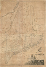
Early map of the District of Maine
Finely engraved map of Nova Scotia, New Brunswick and Maine, while it was still just a district of Massachusetts.
Early county borders for York, Cumberland, Lincoln, Hancock, and Washington are delineated.
The Eastern Boundary of the United States with New Brunswick is a straight line from the Saint Lawrence south to the Bay of Fundy.
![[Portland & Cape Elizabeth to Moskito Island -- Centered on Kennebec River]](https://storage.googleapis.com/raremaps/img/small/50079.jpg)
![[ French & Indian War Battle Plan--Louisbourg ]. Plan De Louisbourg...](https://storage.googleapis.com/raremaps/img/small/57192.jpg)
![[Inhabitants of New France] Einwohner von neu Frankreich](https://storage.googleapis.com/raremaps/img/small/94772.jpg)