|
||

|

|
|

|
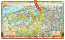
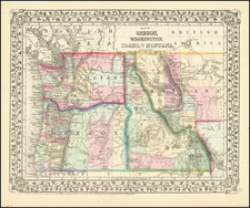
Early Mapping of Mount Rainier - As Mount Tacoma!
An uncommon early map of Pierce County, Washington, showing the layout of the nascent city of Tacoma. The map shows all towns and cities within the county and overlies a grid onto unincorporated areas. The main industries of the county are given particular notice. Radiating away from Tacoma, the economy is seen to be driven by grazing animals, orchard-grown fruit, coal mining, and timber, providing a fascinating early glimpse of life in Pierce County.
In addition to the renaming of Mount Rainier as Mount Tacoma (discussed below), several features on the map are of particular interest. For example, Washington National Park is denoted, despite the fact that a park of this name never existed, and that Mt. Rainier National Park was not founded until 1899. Of further interest is the now-defunct "Summit Mining District" to the east of Mount Tacoma, where "Gold, Silver, Lead etc." can be found.
This map was produced by the Pierce County Immigration Association, and, as such, was likely intended to lure out-of-state workers to move to the county. It was printed locally, in Tacoma, by the Blatchly Co. Lithographers.
Mount Tacoma
On the map, Mount Rainier is renamed Mount Tacoma, reflecting its native name, despite the US Board on Geographic Names' ruling in 1890. This is likely because the name Tacoma enjoyed widespread non-native use after the travel writer Theodore Winthrop referred to the mountain as such in his 1862 text. In addition, renaming the mountain was a point of local pride for residents of the city.
The many glaciers of Mount Tacoma are shown on this map. While the majority have preserved their name to this day, several have changed names. On the east side, "Inter Glacier" and "Blaine Glacier" have been renamed Emmons and Fryingpan, respectively. The size of the glaciers has shrunk considerably on modern maps of the mountain. Some of this shrinkage may be due to difficulties in mapping this high elevation peak, which had first been summited less than three decades prior to the completion of this map.
Rarity
One copy located in OCLC, at the Washington State Library.
![[Collection of 10 manuscript charts and maps depicting the west coast of North America from Monterey, California, to just north of Salisbury Sound, Alaska.]](https://storage.googleapis.com/raremaps/img/small/98898.jpg)