


|
||

|

|
|

|
Stock# 75596
Description
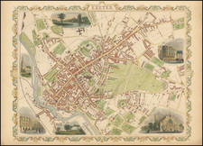
Original antique map of the western Yorkshire Dales and the eastern Lake District, showing the extent of the former English county of Westmorland. This attractive region of hills, rivers, and small towns, now known as the gateway to the Lake District, is attractively portrayed.
The map centers on Kendal and also shows the towns of Kirkby Stephen, Sedbergh, Shap, and Ambleside. Windermere Lake is visible. Distances along roads are provided.
This map was published in 1801 by C. Charles in London.
Condition Description
Original hand-color. Backed on board. Dampstaining at base of map. Small tear in lower part of map.
![[ Atlas of England & Wales ] Geographiae Blauianae Volumen Quintum, quo Anglia, quae est Europae liber undecimus, continentur](https://storage.googleapis.com/raremaps/img/small/99196.jpg)

![[ London to Dorchester and Bensington ] The Road from London to St. David's com Pembroke . . .](https://storage.googleapis.com/raremaps/img/small/100748.jpg)