


|
||

|

|
|

|
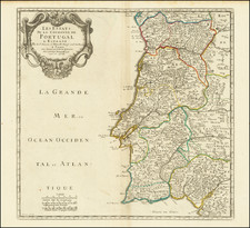
Rare, beautifully engraved, Lafreri-school map of the Iberian Peninsula, published by Domenico Zenoi in 1560.
The map Hispaniae descriptio, engraved by Domenico Zenoi in 1560, offers a portrayal of Spain and Portugal. Its production in Venice during the 16th century reflects the period's advanced cartographic techniques.
Noteworthy features include the Pillars of Hercules and the Spanish monarchy's coat of arms. The map's orientation is marked by the names of the winds – Tramontana, Mediodia, Levante, and Poniente – across the seas. Decorative elements include small territorial coats of arms, eight sailing ships, and three sea monsters. Cities and mountainous areas are depicted pictorially.
Zenoi's map derives from Vicko Paletin's 1551 woodcut map, later copied by Hieronymous Cock in 1553 and Vincenzo Luchini in 1559.
Bifolco & Ronca call this the first Venetian copperplate derivation of Paletino's map of the Iberian Peninsula (1551). But despite a lineage to the Paletino map, Zenoi's is fundamentally a close copy of Luchini's map that was published in Rome a year earlier.
The Lafreri School is a commonly used name for a group of mapmakers, engravers, and publishers who worked in Rome and Venice from ca. 1544 to 1585. The makers, who were loosely connected via business partnerships and collaborations, created maps that were then bound into composite atlases; the maps would be chosen based on the buyer or compiler’s interests. As the maps were initially published as separate-sheets, the style and size of maps included under the umbrella of the “School” differed widely. These differences can also be seen in the surviving Lafreri atlases, which have maps bound in with varying formats including as folded maps, maps with wide, trimmed, or added margins, smaller maps, etc.
The most famous mapmakers of the School included Giacomo Gastaldi and Paolo Forlani, among others. The School’s namesake, Antonio Lafreri, was a map and printseller. His 1572 catalog of his stock, entitled Indice Delle Tavole Moderne Di Geografia Della Maggior Parte Del Mondo, has a similar title to many of the composite atlases and thus his name became associated with the entire output of the larger group.
![[Palma, Tenerife, Gomera, Hierro] Isla Canarias 1a. Hoja](https://storage.googleapis.com/raremaps/img/small/79081.jpg)
![Sevilla, Hispalis ... [on sheet with] Cadiz [and] Malaga](https://storage.googleapis.com/raremaps/img/small/76449.jpg)