|
||

|

|
|

|
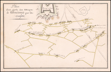
Rare “Lafreri School” bird’s eye view map of the environs of Metz’ published by Bertelli.
The map shows the city shortly after the Treaty of Chambord in 1552. The map mainly focuses on the fortifications, city walls, defense system and the surrounding towns.
In the lower left a key is included naming 54 locations, with more locations marked on the map.
The map also appeared in Giulio Ballino’s De’ Disegni delle più belle illustri città e fortezze del Mondo, published 1569 in Venice, by Zaltieri.
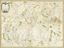
The Lafreri School is a commonly used name for a group of mapmakers, engravers, and publishers who worked in Rome and Venice from ca. 1544 to 1585. The makers, who were loosely connected via business partnerships and collaborations, created maps that were then bound into composite atlases; the maps would be chosen based on the buyer or compiler’s interests. As the maps were initially published as separate-sheets, the style and size of maps included under the umbrella of the “School” differed widely. These differences can also be seen in the surviving Lafreri atlases, which have maps bound in with varying formats including as folded maps, maps with wide, trimmed, or added margins, smaller maps, etc.
The most famous mapmakers of the School included Giacomo Gastaldi and Paolo Forlani, among others. The School’s namesake, Antonio Lafreri, was a map and printseller. His 1572 catalog of his stock, entitled Indice Delle Tavole Moderne Di Geografia Della Maggior Parte Del Mondo, has a similar title to many of the composite atlases and thus his name became associated with the entire output of the larger group.
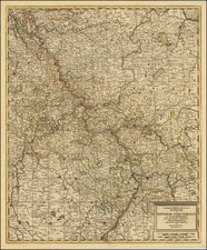
![[ Metz ] Accurate Vorstellung des neuesten Plans der unter französischer Bothmaesigkeit seit dem Crambresischen Frieden 1556 stehenden Bischöflichen Haubtstadt und Vestung Metz, so ehmahlen auch die Haubtstadt im Königreich Austrasien gewesen; an das Tags Liecht gestellet und zu finden in der Homaenn. Officin 1738 | Accurata repraesentatio ichnographica urbis episcopalis in ducatu Lotharingiae, dictae Metae . . . .](https://storage.googleapis.com/raremaps/img/small/102120.jpg)
![[Annotated with Contempary Manuscript Sailing Directions] A New & Correct Draught of the Channell between England & France. . .](https://storage.googleapis.com/raremaps/img/small/80950.jpg)