
This item has been sold, but you can enter your email address to be notified if another example becomes available.


|
||

|

|
|

|
Stock# 7521
Description
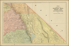
Rare map showing the street car system of San Francisco, including the car lines, transfeer points, and the directions of the street cars at each transfer point. Printed in red and black. While the map was printed to accompany Langley's Directory, it is rarely found in the directory. Oriented with West at the top, as shown by the decorative compass rose. An explanatory note includes a key showing Cable, Electric and Horse Cars and Steam Rail Roads. The Horse Cars are on Potrero, Market, Tenth, Eighth, Sixth, Fifth, Fourth, Buxome, and Townsend, and also on Mongomery, California, Sansome, Washingotn,Jackson and Clay. A marvelous 19th Century San Francisco Map.
![[ Southern California Water Explorations ] Topographical Sketch showing the Outward and Inward Route of A Party, while examining the practicability of a Diversion of the Colorado River for Purposes of Irrigation under the Command of 1st Lieut. Eric Bergland Corps of Engineers, U.S. Army 1875](https://storage.googleapis.com/raremaps/img/small/98208.jpg)

![[Northern San Diego County] Escondido Quadrangle](https://storage.googleapis.com/raremaps/img/small/83567.jpg)