|
||

|

|
|

|
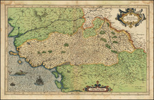
The Siege of Saint-Martin-de-Ré in Exquisite Detail.
Large battle map showing Ile de Ré in fine detail, with British and French warships surrounding the island. The map is highly detailed, including inset plans of two forts, and it was published in Amsterdam by Claesz Janszoon Visscher in 1627. No mention appears to be made of the French lifting the siege, and thus the map can be assumed to be published in August, September, or early October of 1627. The siege was undertaken by the British to create a staging ground for military adventures on the French Atlantic coast. The siege resulted in a victory for the French Crown, and subsequently the defeat of French Huguenot rebels in La Rochelle and elsewhere.
The map is highly detailed, with a number of towns and features named on the Ile de Ré, including the salt pans, the Fort St. Martin, and the Isle de Loye. British ships are seen surrounding Fort S. Martin, with more English troops landing at the southeastern end of the island. On the mainland, La Rochelle is shown fortified, and the map goes northwards to Les Sables-d'Olonne. Throughout the map, roads, fields, and more are shown. Two inset maps show the Fort de St. Partin and the Fort de la Pree. A decorative knight stands holding a shield adorned with the Fleur de Lys.
Text below the map describes the geography of the island and of La Rochelle and the up-to-date history of the battle, naming the number of soldiers involved, day-by-day occurrences, and important people involved. While this text is in Dutch, the majority of the discussion on the map switches between Dutch and French.
The battle shown on this map would be a major turn in European 17th-century events, as it would spell the demise of the Huguenots in France, the end of British involvement in the Thirty Years' War, and the strengthening of the French-Habsburg alliance.
The Siege of Saint-Martin-de-Ré
Perhaps the most important Protestant stronghold during the French Wars of Religion was the coastal town of La Rochelle, which had frequently rebelled against the crown in its desire to gain greater autonomy. Just across a narrow strait from the city was the Ile de Ré, which could be used to control trade in and out of La Rochelle. In the early 1620s, Huguenot rebels had taken over the island, but it had been recaptured in 1625 using British help.
With a population angry at their government for having sided with the French against their coreligionists, and in the face of deteriorating Franco-English relations, the English attempted to capture the now French-held island. At the start of July, 1627, a large English force landed at the south end of the island and managed to establish a beachhead. Ships then proceeded to blockade the Fort St. Martin, and, in September, La Rochelle openly revolted.
The French forces in the city struggled with low supplies, despite Cardinal Richelieu's promise of 30,000 livres to anyone who could deliver fifty barrels of useful goods to the besieged fort. Reinforcements only managed to breakthrough in the beginning of October, meanwhile, English supplies were also low.
In a last-ditch attempt to take Saint Martin, British troops attacked at the end of October, but several major planning errors, including the insufficient length of ladders, led to the British defeat. The British withdrew from Ile de Ré, and La Rochelle eventually capitulated to the French Crown in 1628.
This siege is memorialized in Alexandre Dumas's The Three Musketeers.
Rarity
The map is rare on the market, with the last example having traded in 2009 at Reiss.
![[Biscaya] De Zeecusten van Vrancrijck en Biscaijen tuschen Arcachon en de C. de Machicaco](https://storage.googleapis.com/raremaps/img/small/84355.jpg)
![[Perpignan]](https://storage.googleapis.com/raremaps/img/small/75063.jpg)
![[Royal / Presidential Hunting Grounds] Plan des Forts de St. Germain, Marly et des environs par D. Recope, Sous-Inspecteur des Forets.](https://storage.googleapis.com/raremaps/img/small/79761rd.jpg)