The item illustrated and described below is sold, but we
have another example in stock. To view the example which
is currently being offered for sale, click the
"View Details" button below.

1630 Johannes Cloppenburg
$ 1,100.00


|
||

|

|
|

|
Stock# 74965
Description
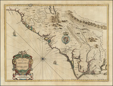
Rare late state of Cloppenberg's map of the Carolinas and parts of Virginia and Georgia, first issued in the Cloppenburg edition of Jansson's Atlas sive Cosmographie in 1630.
The map extends from St. Augustine in the south to just north of Chesepioock Sinus in the north and to the Alleghany Mountains in the west, naming a number of early towns.
States of the Map
- 1630: Engraved Sea
- 1673: Engraved Sea erased
- 1738: Plate #264 at top right corner.
A highly collectable early map of the Southeast.
Reference
Burden #227
Johannes Cloppenburg Biography
Johannes Cloppenburg (sometimes Cloppenburgh; also H. Jan Evertsz and Johannes Everhardus) was a Dutch cartographer. Based in Amsterdam, he was active between roughly 1610 and 1644. He worked closely with the Hondius/Jansson firm and is credited with the 1630 edition of the Atlas Minor.
![[ Southern Railroads ] Railroad Map of the Southern States Shewing the Southern & Southwestern Railway Connections With Philadelphia. 1862 . . . Prepared by Thomas Kimber Jr., Chairman of the Committee on Inland Transportation of the Board of Trade of Philadelphia](https://storage.googleapis.com/raremaps/img/small/103211.jpg)
![[Pamlico Sound] Coast Chart No. 145. Cape Hatteras to Ocracoke Inlet. North Carolina](https://storage.googleapis.com/raremaps/img/small/90723.jpg)