


|
||

|

|
|

|
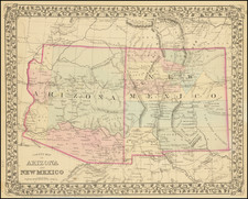
Detailed map of New Mexico and Arizona Territories, colored by county.
Arizona has only 5 counties. Pah-Ute County still shown in Arizona.
Many Indian Tribes are shown, as are Fort Yuma, Ft. Buchanan, Ft. Grant, Ft. Goodwin, Ft. Mojave, Ft. Colorado, Ft. Rock Springs, Ft. Bowie, Ft. McDowell, and Ft. Whipple (all in Arizona) and Ft. McLane, Ft. Bajavd, Ft. Webster, Ft. Cummins, Ft. Selden, Ft. Fillmore, Ft. McCrae, Ft. Craig, Ft. Summer, Ft. Bascomb, Ft. Union, Ft. Barclay, and Ft. Wingate (in New Mexico).
The Gadsden Purchase is referenced. Numerous Gold, Copper and other mines are mentioned. Capt. Marcy's Route, the Comanche Trail (said to be a good wagon route), the Route to Fort Smith, Lieut Abert's Route in 1845, the Caravan Route from Missouri to Santa Fe, Col. Washington's Route in 1849, the Spanish Trail from Santa Fe to the Pacific, Lieut. Col. Cooki's Wagon Route, Gen. Kearney's Route, Whitting & Smith's Route, and a host of other unnamed roads and trails are shown, as are many important mountain passes and springs along the various routes.
One of the more interesting regional maps of the period.
Samuel Augustus Mitchell Jr. inherited the Mitchell Company from his father in 1860. For over thirty years, the company had specialized in the production of school atlases and wall maps of America. They were one of the pioneers on engraving on steel plates. In 1860, Samuel Jr. released the New General Atlas, which had been compiled in house and replaced a previous atlas by Tanner. The elder Mitchell died in 1868 and Samuel Jr. continued the business until the 1890s. At its height, the Mitchell Company employed 250 people and sold 400,000 publications annually.
![[ US-Mexico Border Survey: General Order From the President of the United States Directing William H. Emory to lead the US-Mexico Boundary Survey ]](https://storage.googleapis.com/raremaps/img/small/101837.jpg)
![[ California & Southwest ] Granata Nova Et California](https://storage.googleapis.com/raremaps/img/small/72305.jpg)